National Register of Historic Places listings in Mitchell County, Georgia
This is a list of properties and districts in Mitchell County, Georgia that are listed on the National Register of Historic Places (NRHP).
Map all coordinates using OpenStreetMap
Download coordinates as:
- KML
- GPX (all coordinates)
- GPX (primary coordinates)
- GPX (secondary coordinates)
This National Park Service list is complete through NPS recent listings posted June 21, 2024.[1]
- v
- t
- e
Properties on the National Register of Historic Places in Georgia by county
- Appling
- Atkinson
- Bacon
- Baker
- Baldwin
- Banks
- Barrow
- Bartow
- Ben Hill
- Berrien
- Bibb
- Bleckley
- Brantley
- Brooks
- Bryan
- Bulloch
- Burke
- Butts
- Calhoun
- Camden
- Candler
- Carroll
- Catoosa
- Charlton
- Chatham
- Chattahoochee
- Chattooga
- Cherokee
- Clarke
- Clay
- Clayton
- Clinch
- Cobb
- Coffee
- Colquitt
- Columbia
- Cook
- Coweta
- Crawford
- Crisp
- Dade
- Dawson
- Decatur
- DeKalb
- Dodge
- Dooly
- Dougherty
- Douglas
- Early
- Echols
- Effingham
- Elbert
- Emanuel
- Evans
- Fannin
- Fayette
- Floyd
- Forsyth
- Franklin
- Fulton
- Gilmer
- Glascock
- Glynn
- Gordon
- Grady
- Greene
- Gwinnett
- Habersham
- Hall
- Hancock
- Haralson
- Harris
- Hart
- Heard
- Henry
- Houston
- Irwin
- Jackson
- Jasper
- Jeff Davis
- Jefferson
- Jenkins
- Johnson
- Jones
- Lamar
- Lanier
- Laurens
- Lee
- Liberty
- Lincoln
- Long
- Lowndes
- Lumpkin
- Macon
- Madison
- Marion
- McDuffie
- McIntosh
- Meriwether
- Miller
- Mitchell
- Monroe
- Montgomery
- Morgan
- Murray
- Muscogee
- Newton
- Oconee
- Oglethorpe
- Paulding
- Peach
- Pickens
- Pierce
- Pike
- Polk
- Pulaski
- Putnam
- Quitman
- Rabun
- Randolph
- Richmond
- Rockdale
- Schley
- Screven
- Seminole
- Spalding
- Stephens
- Stewart
- Sumter
- Talbot
- Taliaferro
- Tattnall
- Taylor
- Telfair
- Terrell
- Thomas
- Tift
- Toombs
- Towns
- Treutlen
- Troup
- Turner
- Twiggs
- Union
- Upson
- Walker
- Walton
- Ware
- Warren
- Washington
- Wayne
- Webster
- Wheeler
- White
- Whitfield
- Wilcox
- Wilkes
- Wilkinson
- Worth

Current listings
| [2] | Name on the Register | Image | Date listed[3] | Location | City or town | Description |
|---|---|---|---|---|---|---|
| 1 | Bacon Family Homestead | Upload image | November 25, 1983 (#83003591) | W. Durham St. and Albany Bainbridge Stage Rd. 31°22′43″N 84°10′24″W / 31.37856°N 84.17335°W / 31.37856; -84.17335 (Bacon Family Homestead) | Baconton | |
| 2 | Baconton Commercial Historic District |  | December 1, 1983 (#83003603) | E. Walton and E. Durham Sts., N. Railroad and S. Railroad Aves., and GA 3 31°22′30″N 84°09′42″W / 31.375°N 84.161667°W / 31.375; -84.161667 (Baconton Commercial Historic District) | Baconton | |
| 3 | Camilla Commercial Historic District |  | April 18, 1985 (#85000862) | Roughly bounded by Broad, S. Scott and N. Scott Sts. 31°13′52″N 84°12′37″W / 31.231111°N 84.210278°W / 31.231111; -84.210278 (Camilla Commercial Historic District) | Camilla | |
| 4 | George W. Jackson House | 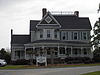 | December 1, 1983 (#83003595) | 333 E. Walton St. 31°22′30″N 84°09′11″E / 31.375077°N 84.152922°E / 31.375077; 84.152922 (George W. Jackson House) | Baconton | 1898-built Late Victorian house now serving as Baconton's city hall |
| 5 | James Price McRee House | 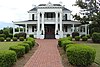 | December 11, 1979 (#79000734) | 181 E. Broad St. 31°13′50″N 84°12′07″W / 31.230556°N 84.201944°W / 31.230556; -84.201944 (James Price McRee House) | Camilla | 1907 Classical Revival-style house currently housing the Southern Georgia Regional Commission |
| 6 | Mount Enon Church and Cemetery | Upload image | December 22, 1983 (#83003596) | Old Stage Coach Rd. 31°23′57″N 84°06′50″W / 31.399167°N 84.113889°W / 31.399167; -84.113889 (Mount Enon Church and Cemetery) | Baconton | |
| 7 | Pelham Commercial Historic District | 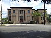 | March 24, 1983 (#83000238) | Roughly bounded by RR tracks, Church, Blythe, Jackson Sts. & Hand Ave. 31°07′31″N 84°09′12″W / 31.125278°N 84.153333°W / 31.125278; -84.153333 (Pelham Commercial Historic District) | Pelham | |
| 8 | South Railroad Historic District | 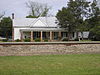 | December 1, 1983 (#83003597) | S. Railroad Ave., GA 3, and Seaboard Coast Line RR tracks 31°22′16″N 84°09′51″W / 31.371111°N 84.164167°W / 31.371111; -84.164167 (South Railroad Historic District) | Baconton | |
| 9 | Walton Street-Church Street Historic District |  | December 1, 1983 (#83003602) | Walton and Church Sts. 31°22′29″N 84°09′24″W / 31.374722°N 84.156667°W / 31.374722; -84.156667 (Walton Street-Church Street Historic District) | Baconton | |
| 10 | Georgia Williams Nursing Home | Upload image | April 8, 2011 (#11000180) | 176 Dyer St. 31°14′12″N 84°12′28″W / 31.23663°N 84.20784°W / 31.23663; -84.20784 (Georgia Williams Nursing Home) | Camilla | Georgia Traveler website |
References
- ^ National Park Service, United States Department of the Interior, "National Register of Historic Places: Weekly List Actions", retrieved June 21, 2024.
- ^ Numbers represent an alphabetical ordering by significant words. Various colorings, defined here, differentiate National Historic Landmarks and historic districts from other NRHP buildings, structures, sites or objects.
- ^ The eight-digit number below each date is the number assigned to each location in the National Register Information System database, which can be viewed by clicking the number.
Wikimedia Commons has media related to National Register of Historic Places in Mitchell County, Georgia.


