National Register of Historic Places listings in Cobb County, Georgia
This is a list of properties and districts in Cobb County, Georgia that are listed on the National Register of Historic Places (NRHP).
Map all coordinates using OpenStreetMap
Download coordinates as:
- KML
- GPX (all coordinates)
- GPX (primary coordinates)
- GPX (secondary coordinates)
This National Park Service list is complete through NPS recent listings posted June 21, 2024.[1]
- v
- t
- e
Properties on the National Register of Historic Places in Georgia by county
- Appling
- Atkinson
- Bacon
- Baker
- Baldwin
- Banks
- Barrow
- Bartow
- Ben Hill
- Berrien
- Bibb
- Bleckley
- Brantley
- Brooks
- Bryan
- Bulloch
- Burke
- Butts
- Calhoun
- Camden
- Candler
- Carroll
- Catoosa
- Charlton
- Chatham
- Chattahoochee
- Chattooga
- Cherokee
- Clarke
- Clay
- Clayton
- Clinch
- Cobb
- Coffee
- Colquitt
- Columbia
- Cook
- Coweta
- Crawford
- Crisp
- Dade
- Dawson
- Decatur
- DeKalb
- Dodge
- Dooly
- Dougherty
- Douglas
- Early
- Echols
- Effingham
- Elbert
- Emanuel
- Evans
- Fannin
- Fayette
- Floyd
- Forsyth
- Franklin
- Fulton
- Gilmer
- Glascock
- Glynn
- Gordon
- Grady
- Greene
- Gwinnett
- Habersham
- Hall
- Hancock
- Haralson
- Harris
- Hart
- Heard
- Henry
- Houston
- Irwin
- Jackson
- Jasper
- Jeff Davis
- Jefferson
- Jenkins
- Johnson
- Jones
- Lamar
- Lanier
- Laurens
- Lee
- Liberty
- Lincoln
- Long
- Lowndes
- Lumpkin
- Macon
- Madison
- Marion
- McDuffie
- McIntosh
- Meriwether
- Miller
- Mitchell
- Monroe
- Montgomery
- Morgan
- Murray
- Muscogee
- Newton
- Oconee
- Oglethorpe
- Paulding
- Peach
- Pickens
- Pierce
- Pike
- Polk
- Pulaski
- Putnam
- Quitman
- Rabun
- Randolph
- Richmond
- Rockdale
- Schley
- Screven
- Seminole
- Spalding
- Stephens
- Stewart
- Sumter
- Talbot
- Taliaferro
- Tattnall
- Taylor
- Telfair
- Terrell
- Thomas
- Tift
- Toombs
- Towns
- Treutlen
- Troup
- Turner
- Twiggs
- Union
- Upson
- Walker
- Walton
- Ware
- Warren
- Washington
- Wayne
- Webster
- Wheeler
- White
- Whitfield
- Wilcox
- Wilkes
- Wilkinson
- Worth

Current listings
| [2] | Name on the Register | Image | Date listed[3] | Location | City or town | Description |
|---|---|---|---|---|---|---|
| 1 | Acworth Downtown Historic District |  | April 19, 2006 (#06000286) | Roughly bounded by Southside Dr., Federal and Lemon Sts, and Senator Richard B. Russell Ave. 34°03′58″N 84°40′44″W / 34.066111°N 84.678889°W / 34.066111; -84.678889 (Acworth Downtown Historic District) | Acworth | |
| 2 | Atlanta-Frasier Street Historic District | 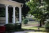 | June 20, 1995 (#95000737) | Atlanta and Frasier Sts. between GA 120 Loop and Dixie Ave. 33°56′43″N 84°32′47″W / 33.945278°N 84.546389°W / 33.945278; -84.546389 (Atlanta-Frasier Street Historic District) | Marietta | |
| 3 | J. C. Bankston Rock House | Upload image | November 25, 1994 (#94001387) | 901 Industrial Dr., Dobbins Air Reserve Base 33°55′30″N 84°31′36″W / 33.92513°N 84.52672°W / 33.92513; -84.52672 (J. C. Bankston Rock House) | Marietta | |
| 4 | Bethel AME Church |  | May 9, 2002 (#02000453) | 4683 Bell St. 34°04′07″N 84°40′41″W / 34.068611°N 84.678056°W / 34.068611; -84.678056 (Bethel AME Church) | Acworth | |
| 5 | Big Shanty Village Historic District |  | March 20, 1980 (#80000995) | Park Ave., Whitfield Pl., Main, Harris, Lewis, and Cherokee Sts. 34°01′27″N 84°36′54″W / 34.024167°N 84.615°W / 34.024167; -84.615 (Big Shanty Village Historic District) | Kennesaw | |
| 6 | Braswell-Carnes House |  | March 1, 1984 (#84000974) | 2430 Burnt Hickory Rd., NW 33°57′57″N 84°37′21″W / 33.96586°N 84.62263°W / 33.96586; -84.62263 (Braswell-Carnes House) | Marietta | |
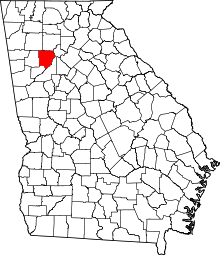
| 7 | Arnoldus Brumby House |  | August 29, 1977 (#77000417) | 472 Powder Springs St. 33°56′37″N 84°33′08″W / 33.943611°N 84.552222°W / 33.943611; -84.552222 (Arnoldus Brumby House) | Marietta | |
| 8 | Hiram Butler House |  | February 2, 1995 (#94001637) | 2382 Pine Mountain Rd., NW. 34°00′35″N 84°37′47″W / 34.009722°N 84.629722°W / 34.009722; -84.629722 (Hiram Butler House) | Kennesaw | |
| 9 | Butner-Mctyre General Store |  | February 1, 2006 (#05001593) | 4455 Marietta St. 33°51′32″N 84°41′04″W / 33.858889°N 84.684444°W / 33.858889; -84.684444 (Butner-Mctyre General Store) | Powder Springs | |
| 10 | Camp McDonald |  | March 20, 1980 (#80000996) | Off U.S. 41 34°01′18″N 84°37′05″W / 34.021667°N 84.618056°W / 34.021667; -84.618056 (Camp McDonald) | Kennesaw | |
| 11 | J. H. Carmichael Farm and General Store | Upload image | June 30, 1980 (#80001002) | SE of Smyrna at 501 Log Cabin Rd. 33°50′36″N 84°29′02″W / 33.843333°N 84.483889°W / 33.843333; -84.483889 (J. H. Carmichael Farm and General Store) | Smyrna | |
| 12 | Israel Causey House |  | August 13, 1975 (#75000584) | 5909 Maxham Rd. 33°48′36″N 84°37′05″W / 33.81°N 84.618056°W / 33.81; -84.618056 (Israel Causey House) | Austell | |
| 13 | Andrew J. Cheney House |  | July 22, 1979 (#79000713) | SW of Marietta at Powder Springs and Bankstone Rds. 33°53′07″N 84°37′07″W / 33.88524°N 84.61854°W / 33.88524; -84.61854 (Andrew J. Cheney House) | Marietta | |
| 14 | Cherokee Street Historic District |  | March 20, 1980 (#80000997) | Cherokee St. 34°01′34″N 84°36′36″W / 34.026111°N 84.61°W / 34.026111; -84.61 (Cherokee Street Historic District) | Kennesaw | |
| 15 | Church Street-Cherokee Street Historic District | Upload image | December 3, 1985 (#85003059) | Roughly bounded by Margaret Ave. and Chicopee Dr., DeSoto Ave., Montgomery and Brumby, and Campbell Hill Sts. 33°57′44″N 84°32′53″W / 33.962222°N 84.548056°W / 33.962222; -84.548056 (Church Street-Cherokee Street Historic District) | Marietta | |
| 16 | Clarkdale Historic District |  | December 23, 1987 (#87002134) | Powder Springs-Austell Rd. 33°49′48″N 84°39′15″W / 33.83°N 84.654167°W / 33.83; -84.654167 (Clarkdale Historic District) | Clarkdale | |
| 17 | Collins Avenue Historic District |  | July 5, 2001 (#01000707) | Collins Ave. 34°04′00″N 84°41′10″W / 34.066667°N 84.686111°W / 34.066667; -84.686111 (Collins Avenue Historic District) | Acworth | |
| 18 | Stephen D. Cowan House |  | November 15, 2002 (#02001299) | 4940 Cowan Rd. 34°04′24″N 84°39′18″W / 34.073333°N 84.655°W / 34.073333; -84.655 (Stephen D. Cowan House) | Acworth | |
| 19 | Frobel-Knight-Borders House | Upload image | July 21, 1995 (#95000901) | 1001 Allgood Rd. 33°58′31″N 84°31′25″W / 33.975278°N 84.523611°W / 33.975278; -84.523611 (Frobel-Knight-Borders House) | Marietta | |
| 20 | The General |  | June 19, 1973 (#73000617) | Big Shanty Museum of Cherokee St. 34°01′25″N 84°36′52″W / 34.023611°N 84.614444°W / 34.023611; -84.614444 (The General) | Kennesaw | Subject of the Great Locomotive Chase of the American Civil War, located at Southern Museum of Civil War and Locomotive History |
| 21 | Gilgal Church Battle Site |  | January 23, 1975 (#75000585) | 9 mi (14 km) W of Marietta on Sandtown Rd. 33°58′18″N 84°39′54″W / 33.971667°N 84.665°W / 33.971667; -84.665 (Gilgal Church Battle Site) | Marietta | |
| 22 | Glover-McLeod-Garrison House |  | March 25, 1977 (#77000418) | 250 Garrison Rd., SE (that part of the street is called Magnolia Chase Dr as of 2017) 33°56′07″N 84°32′52″W / 33.93514°N 84.54785°W / 33.93514; -84.54785 (Glover-McLeod-Garrison House) | Marietta | |
| 23 | Johnston's River Line | Upload image | July 5, 1973 (#73000618) | SE of Mableton off U.S. 78 at Chattachooche River 33°47′31″N 84°31′23″W / 33.791944°N 84.523056°W / 33.791944; -84.523056 (Johnston's River Line) | Mableton | Boundary increase May 18, 2015. |
| 24 | Kennesaw Mountain National Battlefield Park |  | October 15, 1966 (#66000063) | 2 mi (3.2 km) W of Marietta 33°56′59″N 84°35′37″W / 33.949722°N 84.593611°W / 33.949722; -84.593611 (Kennesaw Mountain National Battlefield Park) | Marietta | administered by the National Park Service |
| 25 | Lake Acworth Beach and Bathhouse |  | January 7, 2010 (#09001202) | Lakeshore Dr. 34°03′39″N 84°40′56″W / 34.060706°N 84.682208°W / 34.060706; -84.682208 (Lake Acworth Beach and Bathhouse) | Acworth | |
| 26 | Lemon Street School | Upload image | February 23, 2024 (#100009980) | 350 Lemon Street 33°57′19″N 84°32′31″W / 33.9552°N 84.5420°W / 33.9552; -84.5420 (Lemon Street School) | Marietta | |
| 27 | Robert Mable House and Cemetery | 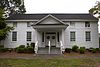 | September 1, 1988 (#87001345) | 5239 Floyd Rd. 33°49′37″N 84°34′25″W / 33.826944°N 84.573611°W / 33.826944; -84.573611 (Robert Mable House and Cemetery) | Mableton | |
| 28 | Marietta National Cemetery |  | September 18, 1998 (#98001170) | 500 Washington Ave. 33°57′04″N 84°32′27″W / 33.951111°N 84.540833°W / 33.951111; -84.540833 (Marietta National Cemetery) | Marietta | |
| 29 | William Gibbs McAdoo House |  | November 17, 1978 (#78000975) | SW of Marietta on GA 5 33°54′28″N 84°36′15″W / 33.907778°N 84.604167°W / 33.907778; -84.604167 (William Gibbs McAdoo House) | Marietta | |
| 30 | Midway Presbyterian Church and Cemetery |  | December 29, 1986 (#86003526) | 4635 Dallas Hwy./GA 120 SW 33°56′37″N 84°41′15″W / 33.943611°N 84.6875°W / 33.943611; -84.6875 (Midway Presbyterian Church and Cemetery) | Powder Springs | |
| 31 | Tarleton Moore House |  | May 31, 2006 (#06000453) | 4784 Northside Dr. 34°04′12″N 84°41′12″W / 34.07°N 84.686667°W / 34.07; -84.686667 (Tarleton Moore House) | Acworth | |
| 32 | North Main Street Historic District | 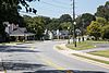 | March 20, 1980 (#80000999) | N. Main St. 34°01′33″N 84°37′14″W / 34.025833°N 84.620556°W / 34.025833; -84.620556 (North Main Street Historic District) | Kennesaw | |
| 33 | Northwest Marietta Historic District |  | June 11, 1975 (#75000586) | Roughly bounded by RR tracks, NW along Kennesaw Ave., McDonald St., and Whitlock Ave. 33°57′36″N 84°33′22″W / 33.96°N 84.556111°W / 33.96; -84.556111 (Northwest Marietta Historic District) | Marietta | |
| 34 | Solomon and Penelopy Pace House | 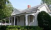 | May 20, 2009 (#09000325) | 3057 Paces Mill Rd. 33°52′01″N 84°27′53″W / 33.86694°N 84.46472°W / 33.86694; -84.46472 (Solomon and Penelopy Pace House) | Vinings | |
| 35 | George A. Power House |  | July 11, 2001 (#01000720) | Hyde Rd. 33°57′38″N 84°23′42″W / 33.960556°N 84.395°W / 33.960556; -84.395 (George A. Power House) | Marietta | |
| 36 | John W. Rice Summer Cottage |  | April 8, 1983 (#83000189) | 254 Concord Rd. 33°50′59″N 84°33′33″W / 33.849722°N 84.559167°W / 33.849722; -84.559167 (John W. Rice Summer Cottage) | Smyrna | |
| 37 | Riverview Carousel at Six Flags Over Georgia |  | January 27, 1995 (#94001639) | 7561 Six Flags Pkwy. 33°46′00″N 84°33′03″W / 33.766667°N 84.550833°W / 33.766667; -84.550833 (Riverview Carousel at Six Flags Over Georgia) | Austell | A carousel at Six Flags Over Georgia |
| 38 | William and Hannah Root House | | March 12, 2014 (#14000061) | 145 Denmead St., NW. 33°57′16″N 84°33′07″W / 33.9545515°N 84.5518412°W / 33.9545515; -84.5518412 (William and Hannah Root House) | Marietta | In the Northwest Marietta Historic District |
| 39 | Ruff's Mill and Concord Covered Bridge |  | November 24, 1980 (#80001001) | 10 Concord Rd., SW 33°50′56″N 84°33′30″W / 33.848889°N 84.558333°W / 33.848889; -84.558333 (Ruff's Mill and Concord Covered Bridge) | Smyrna | |
| 40 | Smith-Manning House |  | December 2, 2014 (#14000969) | 360 Manning Rd. 33°56′38″N 84°34′56″W / 33.943866°N 84.582099°W / 33.943866; -84.582099 (Smith-Manning House) | Marietta | |
| 41 | Sope Creek Ruins |  | April 27, 1973 (#73000619) | Address Restricted (at the intersection of Paper Mill Road and Sope Creek) 33°56′26″N 84°26′16″W / 33.94045°N 84.4378°W / 33.94045; -84.4378 (Sope Creek Ruins) | Marietta | |
| 42 | Summers Street Historic District |  | March 20, 1980 (#80001000) | Summers St. 34°01′10″N 84°36′49″W / 34.019444°N 84.613611°W / 34.019444; -84.613611 (Summers Street Historic District) | Kennesaw | |
| 43 | Taylor-Brawner House and Brawner Sanitarium |  | March 27, 2012 (#12000149) | 3180 Atlanta Rd 33°52′32″N 84°30′24″W / 33.87553°N 84.50678°W / 33.87553; -84.50678 (Taylor-Brawner House and Brawner Sanitarium) | Smyrna | website[usurped] |
| 44 | Union Field Fortifications at Henderson Road |  | May 18, 2015 (#15000223) | 6000 Henderson Rd., SE. 33°48′24″N 84°31′21″W / 33.8066°N 84.5225°W / 33.8066; -84.5225 (Union Field Fortifications at Henderson Road) | Mableton vicinity | |
| 45 | Washington Avenue Historic District | Upload image | August 10, 1989 (#89001102) | Roughly bounded by Lawrence St., Rigsby St., Washington Ave., and Haynes St. 33°57′09″N 84°32′36″W / 33.9525°N 84.543333°W / 33.9525; -84.543333 (Washington Avenue Historic District) | Marietta | |
| 46 | Whitlock Avenue Historic District | Upload image | September 14, 1989 (#89001218) | Roughly bounded by McCord St., Oakmont St., Whitlock Ave., Powder Springs Rd., Trammel St., Maxwell Ave., and Hazel St. 33°57′04″N 84°33′26″W / 33.951111°N 84.557222°W / 33.951111; -84.557222 (Whitlock Avenue Historic District) | Marietta | |
| 47 | Zion Baptist Church |  | July 11, 1990 (#90001026) | 149 Haynes St. 33°57′18″N 84°32′51″W / 33.955°N 84.5475°W / 33.955; -84.5475 (Zion Baptist Church) | Marietta |
Former listing
| [2] | Name on the Register | Image | Date listed | Date removed | Location | City or town | Description |
|---|---|---|---|---|---|---|---|
| 1 | John S. Gibson Farmhouse | Upload image | March 20, 1980 (#80000998) | October 28, 2009 | 3370 Cherokee St. 34°02′07″N 84°36′18″W / 34.0353°N 84.605°W / 34.0353; -84.605 (John S. Gibson Farmhouse) | Kennesaw |
References
- ^ National Park Service, United States Department of the Interior, "National Register of Historic Places: Weekly List Actions", retrieved June 21, 2024.
- ^ a b Numbers represent an alphabetical ordering by significant words. Various colorings, defined here, differentiate National Historic Landmarks and historic districts from other NRHP buildings, structures, sites or objects.
- ^ The eight-digit number below each date is the number assigned to each location in the National Register Information System database, which can be viewed by clicking the number.
Wikimedia Commons has media related to National Register of Historic Places in Cobb County, Georgia.


