National Register of Historic Places listings in Lake County, Illinois

This is a list of the National Register of Historic Places listings in Lake County, Illinois.
This is intended to be a complete list of the properties and districts on the National Register of Historic Places in Lake County, Illinois, United States. Latitude and longitude coordinates are provided for many National Register properties and districts; these locations may be seen together in a map.[1]
There are 97 properties and districts listed on the National Register in the county, including two National Historic Landmarks. Another three properties were once listed but have been removed.
This National Park Service list is complete through NPS recent listings posted June 21, 2024.[2]
Map all coordinates using OpenStreetMap
Download coordinates as:
- KML
- GPX (all coordinates)
- GPX (primary coordinates)
- GPX (secondary coordinates)
Current listings
| [3] | Name on the Register[4] | Image | Date listed[5] | Location | City or town | Description |
|---|---|---|---|---|---|---|
| 1 | Mary W. Adams House |  | September 29, 1982 (#82002552) | 1923 Lake Avenue 42°11′15″N 87°47′21″W / 42.1875°N 87.789167°W / 42.1875; -87.789167 (Mary W. Adams House) | Highland Park | |
| 2 | David Adler Estate |  | November 22, 1999 (#99001380) | 1700 North Milwaukee Avenue 42°18′08″N 87°57′24″W / 42.302222°N 87.956667°W / 42.302222; -87.956667 (David Adler Estate) | Libertyville | |
| 3 | Mrs. Isaac D. Adler House |  | August 28, 2002 (#02000901) | 1480 North Milwaukee Avenue 42°18′02″N 87°57′08″W / 42.30069°N 87.952318°W / 42.30069; -87.952318 (Mrs. Isaac D. Adler House) | Libertyville | |
| 4 | J. Ogden Armour House |  | June 28, 1982 (#82002578) | 1500 West Kennedy Road 42°14′53″N 87°53′27″W / 42.248056°N 87.890833°W / 42.248056; -87.890833 (J. Ogden Armour House) | Lake Forest | |
| 5 | Lester Armour House |  | May 3, 1984 (#84001131) | Sheridan Road 42°17′34″N 87°50′04″W / 42.292778°N 87.834444°W / 42.292778; -87.834444 (Lester Armour House) | Lake Bluff | |
| 6 | Philip D. Armour III House |  | November 15, 1996 (#96001342) | 900 Armour Drive 42°17′20″N 87°51′11″W / 42.288889°N 87.853056°W / 42.288889; -87.853056 (Philip D. Armour III House) | Lake Bluff | |
| 7 | Barrington Historic District |  | May 16, 1986 (#86001047) | Roughly bounded by Chicago and Northwestern Railroad, South Spring and Grove Streets, East Hillside and West Coolidge, and Dundee Avenues 42°09′02″N 88°08′13″W / 42.150556°N 88.136944°W / 42.150556; -88.136944 (Barrington Historic District) | Barrington | |
| 8 | Ross J. Beatty House |  | September 29, 1982 (#82002553) | 344 Ravine Drive 42°10′53″N 87°47′23″W / 42.181389°N 87.789722°W / 42.181389; -87.789722 (Ross J. Beatty House) | Highland Park | |
| 9 | Ross Beatty House |  | September 29, 1982 (#82002554) | 1499 Sheridan Road 42°10′44″N 87°47′14″W / 42.178889°N 87.787222°W / 42.178889; -87.787222 (Ross Beatty House) | Highland Park | |
| 10 | A. G. Becker Property |  | November 15, 1984 (#84000343) | 405 Sheridan Road 42°09′41″N 87°46′05″W / 42.161389°N 87.768056°W / 42.161389; -87.768056 (A. G. Becker Property) | Highland Park | |
| 11 | Edward H. Bennett House and Studio |  | March 3, 1995 (#95000196) | 89 East Deerpath 42°15′01″N 87°50′41″W / 42.250278°N 87.844722°W / 42.250278; -87.844722 (Edward H. Bennett House and Studio) | Lake Forest | |
| 12 | William McCormick Blair Estate |  | January 31, 2008 (#07001476) | 982 Sheridan Road 42°17′17″N 87°50′45″W / 42.288194°N 87.845833°W / 42.288194; -87.845833 (William McCormick Blair Estate) | Lake Bluff | |
| 13 | Joseph T. Bowen Country Club |  | November 30, 1978 (#78003400) | 1917 North Sheridan Road 42°23′16″N 87°49′52″W / 42.387810°N 87.831174°W / 42.387810; -87.831174 (Joseph T. Bowen Country Club) | Waukegan | |
| 14 | Braeside School |  | September 29, 1982 (#82002555) | 124 Pierce Road 42°09′19″N 87°46′19″W / 42.155278°N 87.771944°W / 42.155278; -87.771944 (Braeside School) | Highland Park | |
| 15 | Robert Parker Coffin Bridge |  | June 11, 2018 (#100001672) | Robert Parker Coffin Rd. over Buffalo Cr. 42°10′39″N 87°59′59″W / 42.1775°N 87.9998°W / 42.1775; -87.9998 (Robert Parker Coffin Bridge) | Long Grove | |
| 16 | Camp Logan National Guard Rifle Range Historic District |  | June 9, 2000 (#00000640) | Illinois Beach State Park 42°28′06″N 87°48′31″W / 42.468333°N 87.808611°W / 42.468333; -87.808611 (Camp Logan National Guard Rifle Range Historic District) | Zion | |
| 17 | Albert Campbell House |  | September 29, 1982 (#82002556) | 434 Marshman 42°10′08″N 87°46′57″W / 42.168889°N 87.7825°W / 42.168889; -87.7825 (Albert Campbell House) | Highland Park | |
| 18 | Catlow Theater |  | August 21, 1989 (#89001112) | 112–116 West Main Street 42°09′16″N 88°08′12″W / 42.154444°N 88.136667°W / 42.154444; -88.136667 (Catlow Theater) | Barrington | |
| 19 | Chicago, Milwaukee and St. Paul Railway Passenger Depot |  | February 5, 1998 (#98000066) | 860 Deerfield Road 42°10′04″N 87°51′00″W / 42.167778°N 87.85°W / 42.167778; -87.85 (Chicago, Milwaukee and St. Paul Railway Passenger Depot) | Deerfield | |
| 20 | Church of the St. Sava Serbian Orthodox Monastery |  | September 6, 1979 (#79000850) | North of Libertyville on North Milwaukee Avenue 42°20′01″N 87°57′03″W / 42.333596°N 87.950751°W / 42.333596; -87.950751 (Church of the St. Sava Serbian Orthodox Monastery) | Libertyville | |
| 21 | Richard Churchill House |  | September 29, 1982 (#82002557) | 1214 Green Bay Road 42°10′28″N 87°47′49″W / 42.1744°N 87.7969°W / 42.1744; -87.7969 (Richard Churchill House) | Highland Park | |
| 22 | Cook Memorial Library |  | August 16, 2001 (#01000867) | 413 North Milwaukee Avenue 42°17′14″N 87°57′19″W / 42.2872°N 87.9553°W / 42.2872; -87.9553 (Cook Memorial Library) | Libertyville | 1878 house of contractor and politician Ansel B. Cook, converted to a public library in 1921. Now a Libertyville-Mundelein Historical Society house museum.[6] |
| 23 | Deerpath Hill Estates Historic District |  | August 7, 2006 (#06000676) | Roughly bounded by Northcliffe Way, King Muir Road and Waukegan Road 42°14′44″N 87°52′13″W / 42.2456°N 87.8703°W / 42.2456; -87.8703 (Deerpath Hill Estates Historic District) | Lake Forest | |
| 24 | Deerpath Inn |  | May 11, 1992 (#92000482) | 255 East Illinois Road 42°14′59″N 87°50′27″W / 42.2497°N 87.8408°W / 42.2497; -87.8408 (Deerpath Inn) | Lake Forest | |
| 25 | Dewey House |  | May 8, 1985 (#85001008) | Veterans Administration Medical Center 42°18′13″N 87°51′34″W / 42.3036°N 87.8594°W / 42.3036; -87.8594 (Dewey House) | North Chicago | |
| 26 | Henry Dubin House |  | September 29, 1982 (#82002558) | 441 Cedar 42°10′19″N 87°47′12″W / 42.1719°N 87.7867°W / 42.1719; -87.7867 (Henry Dubin House) | Highland Park | |
| 27 | Mrs. C. Morse Ely House |  | November 8, 2000 (#00001339) | 111 Moffett Road 42°16′18″N 87°49′57″W / 42.2717°N 87.8325°W / 42.2717; -87.8325 (Mrs. C. Morse Ely House) | Lake Bluff | |
| 28 | Evert House |  | September 29, 1982 (#82002559) | 2687 Logan 42°12′06″N 87°48′20″W / 42.2017°N 87.8056°W / 42.2017; -87.8056 (Evert House) | Highland Park | |
| 29 | Mildred and Abel Fagen House | Upload image | February 4, 2021 (#100006090) | 1711 Devonshire Ln. 42°12′30″N 87°53′17″W / 42.2084°N 87.8881°W / 42.2084; -87.8881 (Mildred and Abel Fagen House) | Lake Forest | |
| 30 | Harold Florsheim House |  | September 29, 1982 (#82002560) | 650 Sheridan Road 42°09′51″N 87°46′22″W / 42.1642°N 87.7728°W / 42.1642; -87.7728 (Harold Florsheim House) | Highland Park | |
| 31 | Fort Sheridan Historic District |  | September 29, 1980 (#80001379) | Off Illinois Route 22 42°13′03″N 87°48′42″W / 42.2175°N 87.8117°W / 42.2175; -87.8117 (Fort Sheridan Historic District) | Fort Sheridan | |
| 32 | Louis Fredrick House | Upload image | June 24, 2019 (#100003649) | 19 W. County Line Rd. 42°09′15″N 88°11′04″W / 42.1543°N 88.1845°W / 42.1543; -88.1845 (Louis Fredrick House) | Barrington | |
| 33 | Mrs. Frank Geyso Houses |  | September 29, 1982 (#82002561) | 450 and 456 Woodland Road 42°09′41″N 87°46′39″W / 42.1614°N 87.7775°W / 42.1614; -87.7775 (Mrs. Frank Geyso Houses) | Highland Park | |
| 34 | Granville-Mott House |  | September 29, 1982 (#82002562) | 80 Laurel Avenue 42°11′17″N 87°47′16″W / 42.1881°N 87.7878°W / 42.1881; -87.7878 (Granville-Mott House) | Highland Park | |
| 35 | Great Lakes Naval Training Station |  | September 15, 1986 (#86002890) | Bounded by Cluverius Avenue, Lake Michigan, G Street, and Sheridan Road 42°18′46″N 87°50′03″W / 42.3128°N 87.8342°W / 42.3128; -87.8342 (Great Lakes Naval Training Station) | North Chicago | |
| 36 | Green Bay Road Historic District |  | November 7, 1995 (#95001235) | Roughly, area surrounding 10 S to 1596 N Green Bay Road and Ahwahnee Road 42°15′43″N 87°50′52″W / 42.2619°N 87.8478°W / 42.2619; -87.8478 (Green Bay Road Historic District) | Lake Forest | |
| 37 | John Griffith Store Building |  | February 5, 2003 (#02001755) | 103–113 East Scranton Avenue 42°16′53″N 87°50′37″W / 42.2814°N 87.8436°W / 42.2814; -87.8436 (John Griffith Store Building) | Lake Bluff | |
| 38 | Grigsby Estate |  | May 12, 1987 (#87000649) | 125 Buckley Road 42°10′20″N 88°10′43″W / 42.1722°N 88.1786°W / 42.1722; -88.1786 (Grigsby Estate) | Barrington Hills | |
| 39 | David Hall House |  | August 25, 2014 (#14000506) | 25420 W. Cedar Crest Ln. 42°25′29″N 88°07′46″W / 42.4248°N 88.1295°W / 42.4248; -88.1295 (David Hall House) | Lake Villa | |
| 40 | Hazel Avenue/Prospect Avenue Historic District |  | September 29, 1982 (#82002563) | St. Johns, Hazel, Dale, Forest, and Prospect Avenues 42°11′01″N 87°47′38″W / 42.1836°N 87.7939°W / 42.1836; -87.7939 (Hazel Avenue/Prospect Avenue Historic District) | Highland Park | |
| 41 | Frank Hibbard Estate House-Deerpath Hill Estates |  | May 12, 2006 (#06000379) | 301 North Chiltern Dr. 42°14′51″N 87°51′52″W / 42.2475°N 87.8644°W / 42.2475; -87.8644 (Frank Hibbard Estate House-Deerpath Hill Estates) | Lake Forest | |
| 42 | Highland Park Water Tower |  | September 29, 1982 (#82002564) | North of Central Green Bay Road 42°11′09″N 87°48′15″W / 42.185833°N 87.804167°W / 42.185833; -87.804167 (Highland Park Water Tower) | Highland Park | |
| 43 | Samuel Holmes House |  | September 29, 1982 (#82002565) | 2693 Sheridan Road 42°12′09″N 87°47′50″W / 42.2025°N 87.797222°W / 42.2025; -87.797222 (Samuel Holmes House) | Highland Park | |
| 44 | Holy Family Church |  | August 21, 2003 (#03000780) | 1840 Lincoln Street 42°19′30″N 87°50′34″W / 42.325°N 87.842778°W / 42.325; -87.842778 (Holy Family Church) | North Chicago | |
| 45 | Hotel Waukegan |  | October 28, 1994 (#94001269) | 102 Washington Street 42°21′35″N 87°49′48″W / 42.359722°N 87.830000°W / 42.359722; -87.830000 (Hotel Waukegan) | Waukegan | |
| 46 | House at 380 Chiltern Drive-Deerpath Hill Estates |  | May 12, 2006 (#06000378) | 380 Chiltern Dr. 42°14′56″N 87°51′55″W / 42.248889°N 87.865278°W / 42.248889; -87.865278 (House at 380 Chiltern Drive-Deerpath Hill Estates) | Lake Forest | |
| 47 | House at 965 Castlegate Court-Deerpath Hill Estates |  | May 12, 2006 (#06000382) | 965 Castlegate Court 42°15′16″N 87°52′14″W / 42.254444°N 87.870556°W / 42.254444; -87.870556 (House at 965 Castlegate Court-Deerpath Hill Estates) | Lake Forest | |
| 48 | Humer Building |  | September 29, 1982 (#82002566) | 1894 Sheridan Road 42°11′13″N 87°47′53″W / 42.186944°N 87.798056°W / 42.186944; -87.798056 (Humer Building) | Highland Park | |
| 49 | Jean Butz James Museum of the Highland Park Historical Society |  | September 29, 1982 (#82002567) | 326 Central Avenue 42°11′14″N 87°47′39″W / 42.187222°N 87.794167°W / 42.187222; -87.794167 (Jean Butz James Museum of the Highland Park Historical Society) | Highland Park | |
| 50 | Jens Jensen Summer House and Studio |  | June 19, 1991 (#91000795) | 930–950 Dean Avenue 42°10′12″N 87°46′41″W / 42.17°N 87.778056°W / 42.17; -87.778056 (Jens Jensen Summer House and Studio) | Highland Park | |
| 51 | Noble Judah Estate |  | August 3, 1990 (#90001197) | 111 and 211 West Westminster Street 42°15′09″N 87°51′00″W / 42.2525°N 87.85°W / 42.2525; -87.85 (Noble Judah Estate) | Lake Forest | |
| 52 | Karcher Hotel |  | August 9, 2002 (#02000845) | 405 Washington Street 42°21′34″N 87°50′03″W / 42.359444°N 87.834167°W / 42.359444; -87.834167 (Karcher Hotel) | Waukegan | |
| 53 | Lake Bluff Uptown Commercial Historic District |  | November 15, 2006 (#06001021) | 20, 31–113 East Scranton, 26-40 (even) East Center Avenue, and 550 North Sheridan 42°16′46″N 87°50′40″W / 42.279444°N 87.844444°W / 42.279444; -87.844444 (Lake Bluff Uptown Commercial Historic District) | Lake Bluff | The historic downtown district of Lake Bluff, Illinois, United States. There are fourteen properties in the district; of these, six buildings, one site, and one object contribute to its historic fabric as contributing properties. |
| 54 | Lake Forest Cemetery |  | May 30, 2001 (#01000597) | 1525 North Lake Road 42°15′52″N 87°49′54″W / 42.264444°N 87.831667°W / 42.264444; -87.831667 (Lake Forest Cemetery) | Lake Forest | |
| 55 | Lake Forest Historic District |  | January 26, 1978 (#78001161) | Roughly bounded by Western, Westleigh, Lake Michigan, and the northern city limits 42°15′03″N 87°49′40″W / 42.250833°N 87.827778°W / 42.250833; -87.827778 (Lake Forest Historic District) | Lake Forest | |
| 56 | Robert P. Lamont House |  | November 12, 1993 (#93001240) | 810 South Ridge Road 42°13′25″N 87°51′21″W / 42.223611°N 87.855833°W / 42.223611; -87.855833 (Robert P. Lamont House) | Lake Forest | |
| 57 | Haerman Lanzl House |  | September 29, 1982 (#82002568) | 1635 Linden 42°10′56″N 87°47′34″W / 42.182222°N 87.792778°W / 42.182222; -87.792778 (Haerman Lanzl House) | Highland Park | |
| 58 | Clifford Milton Leonard Farm |  | August 10, 2000 (#00000944) | 550, 561, 565, 570, 575, 579 Hathaway Circle 42°14′59″N 87°52′29″W / 42.249722°N 87.874722°W / 42.249722; -87.874722 (Clifford Milton Leonard Farm) | Lake Forest | |
| 59 | Lloyd Lewis House |  | June 15, 1982 (#82002579) | 153 Little Saint Mary's Road 42°15′37″N 87°56′08″W / 42.260278°N 87.935556°W / 42.260278; -87.935556 (Lloyd Lewis House) | Libertyville | |
| 60 | Libertyville Town Hall | Upload image | August 10, 2022 (#100007992) | 715 North Milwaukee Ave. 42°17′24″N 87°57′18″W / 42.2900°N 87.9549°W / 42.2900; -87.9549 (Libertyville Town Hall) | Libertyville | |
| 61 | Libertyville High School Brainerd Building |  | July 16, 2008 (#08000678) | 416 W. Park Ave. 42°17′02″N 87°57′31″W / 42.283961°N 87.958606°W / 42.283961; -87.958606 (Libertyville High School Brainerd Building) | Libertyville | 1917 Neoclassical school—the area's first high school building—with a 1929 Gothic Revival gymnasium.[7] Demolished in 2014.[8] |
| 62 | Lichtstern House |  | September 29, 1982 (#82002569) | 105 South Deere Park Dr. 42°09′17″N 87°45′46″W / 42.154722°N 87.762778°W / 42.154722; -87.762778 (Lichtstern House) | Highland Park | |
| 63 | Linden Park Place-Belle Avenue Historic District |  | December 13, 1983 (#83003580) | Roughly bounded by Sheridan Road, Elm Pl., Linden, Park, and Central Avenues 42°11′16″N 87°47′38″W / 42.187778°N 87.793889°W / 42.187778; -87.793889 (Linden Park Place-Belle Avenue Historic District) | Highland Park | |
| 64 | Howard and Lucy Linn House | Upload image | November 15, 2005 (#05001257) | 555 Shoreacres Dr. 42°17′55″N 87°50′04″W / 42.298611°N 87.834444°W / 42.298611; -87.834444 (Howard and Lucy Linn House) | Lake Bluff | |
| 65 | Ernest Loeb House |  | May 18, 1983 (#83000321) | 1425 Waverly 42°10′44″N 87°46′57″W / 42.178889°N 87.7825°W / 42.178889; -87.7825 (Ernest Loeb House) | Highland Park | |
| 66 | Mr. Fred L. Mandel Jr. House |  | December 22, 2009 (#09001122) | 2479 Woodbridge Lane 42°11′53″N 87°47′40″W / 42.197947°N 87.794375°W / 42.197947; -87.794375 (Mr. Fred L. Mandel Jr. House) | Highland Park | |
| 67 | Maple Avenue/Maple Lane Historic District |  | September 29, 1982 (#82002570) | Maple Avenue and Maple Lane between St. Johns Avenue and Sheridan Road 42°11′41″N 87°47′58″W / 42.194722°N 87.799444°W / 42.194722; -87.799444 (Maple Avenue/Maple Lane Historic District) | Highland Park | |
| 68 | George Madison Millard House |  | September 29, 1982 (#82002571) | 1689 Lake Avenue 42°11′08″N 87°47′16″W / 42.185619°N 87.787675°W / 42.185619; -87.787675 (George Madison Millard House) | Highland Park | |
| 69 | Sylvester Millard House |  | September 29, 1982 (#82002572) | 1623 Sylvester Pl. 42°10′56″N 87°47′02″W / 42.182222°N 87.783889°W / 42.182222; -87.783889 (Sylvester Millard House) | Highland Park | |
| 70 | Millburn Historic District |  | September 18, 1979 (#79000851) | U.S. 45, Millburn and Grass Lake Roads 42°25′34″N 87°59′57″W / 42.426111°N 87.999167°W / 42.426111; -87.999167 (Millburn Historic District) | Millburn | |
| 71 | Mineola Hotel |  | July 29, 1979 (#79003785) | 91 North Cora Street 42°24′12″N 88°10′33″W / 42.403333°N 88.175833°W / 42.403333; -88.175833 (Mineola Hotel) | Fox Lake | |
| 72 | Robert Hosmer Morse House |  | August 10, 2000 (#00000947) | 1301 Knollwood Circle 42°16′26″N 87°52′44″W / 42.273889°N 87.878889°W / 42.273889; -87.878889 (Robert Hosmer Morse House) | Lake Forest | |
| 73 | Near North Historic District |  | May 3, 1978 (#78001162) | Roughly bounded by Ash Street, railroad tracks, and Glen Flora Avenue 42°22′04″N 87°49′47″W / 42.367778°N 87.829722°W / 42.367778; -87.829722 (Near North Historic District) | Waukegan | |
| 74 | North Shore Sanitary District Tower |  | June 30, 1983 (#83000322) | Cary Avenue 42°10′04″N 87°46′18″W / 42.167778°N 87.771667°W / 42.167778; -87.771667 (North Shore Sanitary District Tower) | Highland Park | |
| 75 | Henry I. Paddock House |  | May 30, 2001 (#01000596) | 346 Sheridan Road 42°29′16″N 87°49′21″W / 42.487694°N 87.822500°W / 42.487694; -87.822500 (Henry I. Paddock House) | Winthrop Harbor | |
| 76 | George Pick House |  | September 29, 1982 (#82002574) | 970 Sheridan Road 42°10′10″N 87°46′24″W / 42.169444°N 87.773333°W / 42.169444; -87.773333 (George Pick House) | Highland Park | |
| 77 | Proctor Building |  | February 5, 1998 (#98000064) | 520–30 North Milwaukee Avenue 42°17′18″N 87°57′15″W / 42.288332°N 87.954188°W / 42.288332; -87.954188 (Proctor Building) | Libertyville | 1903 commercial building. |
| 78 | Public Service Building |  | December 8, 1983 (#83003581) | 344-354 North Milwaukee Avenue 42°17′12″N 87°57′13″W / 42.286667°N 87.953611°W / 42.286667; -87.953611 (Public Service Building) | Libertyville | 1928 Gothic Tudor Revival/Neo-Plateresque commercial building built for utility magnate Samuel Insull.[9] |
| 79 | Ragdale |  | June 3, 1976 (#76000717) | 1230 North Green Bay Road 42°15′45″N 87°51′02″W / 42.2625°N 87.850556°W / 42.2625; -87.850556 (Ragdale) | Lake Forest | |
| 80 | Ravinia Park Historic District |  | September 29, 1982 (#82002575) | Roughly bounded by Lambert Tree Avenue, Sheridan Road, St. Johns Avenue, Rambler Lane, and Ravinia Park Avenue 42°09′35″N 87°46′26″W / 42.159722°N 87.773889°W / 42.159722; -87.773889 (Ravinia Park Historic District) | Highland Park | |
| 81 | Mrs. Kersey Coates Reed House |  | March 2, 2001 (#01000178) | 1315 North Lake Road 42°15′47″N 87°49′38″W / 42.263056°N 87.827222°W / 42.263056; -87.827222 (Mrs. Kersey Coates Reed House) | Lake Forest | |
| 82 | Rosewood Park |  | September 29, 1982 (#82002576) | Roger Williams Avenue 42°09′58″N 87°46′22″W / 42.166111°N 87.772778°W / 42.166111; -87.772778 (Rosewood Park) | Highland Park | |
| 83 | Edward L. Ryerson Area Historic District | 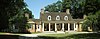 | February 29, 1996 (#96000086) | 21950 North Riverwoods Road 42°10′39″N 87°54′39″W / 42.1775°N 87.910833°W / 42.1775; -87.910833 (Edward L. Ryerson Area Historic District) | Deerfield | |
| 84 | Shiloh House |  | May 12, 1977 (#77000488) | 1300 Shiloh Boulevard 42°27′02″N 87°49′38″W / 42.450694°N 87.827222°W / 42.450694; -87.827222 (Shiloh House) | Zion | |
| 85 | John Taylor Snite House |  | August 19, 2003 (#03000790) | 225 North Deere Park Avenue E 42°09′29″N 87°45′42″W / 42.158056°N 87.761667°W / 42.158056; -87.761667 (John Taylor Snite House) | Highland Park | |
| 86 | C. S. Soule House |  | September 29, 1982 (#82002577) | 304 Laurel Avenue 42°11′10″N 87°47′33″W / 42.186111°N 87.7925°W / 42.186111; -87.7925 (C. S. Soule House) | Highland Park | |
| 87 | Adlai E. Stevenson II Farm |  | September 14, 2003 (#03000918) | 25200 N. Saint Mary's Rd. 42°13′44″N 87°55′50″W / 42.228843°N 87.93056°W / 42.228843; -87.93056 (Adlai E. Stevenson II Farm) | Mettawa | |
| 88 | Louis F. Swift House |  | November 18, 2005 (#05001256) | 255 East Foster Place 42°14′09″N 87°50′28″W / 42.235833°N 87.841111°W / 42.235833; -87.841111 (Louis F. Swift House) | Lake Forest | |
| 89 | George E. Van Hagen House | Upload image | January 12, 2016 (#15000966) | 12 W. County Line Rd. 42°09′15″N 88°10′50″W / 42.154196°N 88.180671°W / 42.154196; -88.180671 (George E. Van Hagen House) | Barrington Hills | |
| 90 | Vine-Oakwood-Green Bay Road Historic District |  | March 28, 1980 (#80001381) | Green Bay Road, East Vine and North Oakwood Avenues 42°14′52″N 87°50′29″W / 42.247778°N 87.841389°W / 42.247778; -87.841389 (Vine-Oakwood-Green Bay Road Historic District) | Lake Forest | |
| 91 | Water Tower, Building 49 |  | December 4, 1974 (#74000764) | Leonard Wood Avenue 42°12′59″N 87°48′42″W / 42.216389°N 87.811667°W / 42.216389; -87.811667 (Water Tower, Building 49) | Fort Sheridan | |
| 92 | Waukegan Building |  | November 21, 2002 (#02001355) | 4 South Genesee Street 42°21′34″N 87°49′54″W / 42.359444°N 87.831667°W / 42.359444; -87.831667 (Waukegan Building) | Waukegan | |
| 93 | Waukegan Public Library |  | December 31, 2013 (#13001003) | 1 N. Sheridan Rd. 42°21′35″N 87°49′46″W / 42.359722°N 87.829444°W / 42.359722; -87.829444 (Waukegan Public Library) | Waukegan | |
| 94 | West Park Neighborhood Historic District |  | November 14, 2012 (#07000900) | Roughly bounded by Green Bay Rd., Westminster, Oakwood, and Atteridge Rds. 42°15′19″N 87°50′41″W / 42.255173°N 87.844856°W / 42.255173; -87.844856 (West Park Neighborhood Historic District) | Lake Forest | |
| 95 | Westover Road Non-Commissioned Officers' Housing Historic District |  | October 1, 2009 (#08000399) | 339-355 Westover Rd. 42°12′50″N 87°49′00″W / 42.213781°N 87.816544°W / 42.213781; -87.816544 (Westover Road Non-Commissioned Officers' Housing Historic District) | Highwood | |
| 96 | Ward Winfield Willits House | 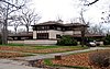 | November 24, 1980 (#80001380) | 1445 Sheridan Road 42°10′44″N 87°47′12″W / 42.178889°N 87.786667°W / 42.178889; -87.786667 (Ward Winfield Willits House) | Highland Park | |
| 97 | Zion Chapter House |  | November 28, 1980 (#80001382) | 2715 Emmaus Avenue 42°26′44″N 87°49′42″W / 42.445556°N 87.828333°W / 42.445556; -87.828333 (Zion Chapter House) | Zion |
Former listing
| [3] | Name on the Register | Image | Date listed | Date removed | Location | City or town | Description |
|---|---|---|---|---|---|---|---|
| 1 | Jewel Tea Company, Inc. | 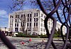 | February 3, 2004 (#03001462) | January 2, 2020 | 511 Lake Zurich Road 42°09′40″N 88°07′40″W / 42.161111°N 88.127778°W / 42.161111; -88.127778 (Jewel Tea Company, Inc.) | Barrington | Building demolished in 2004.[10] |
| 2 | Obee House | Upload image | September 29, 1982 (#82002573) | January 2, 2020 | 1642 Green Bay Road 42°11′08″N 87°48′47″W / 42.185556°N 87.813056°W / 42.185556; -87.813056 (Obee House) | Highland Park | Demolished in late 1990s.[11] |
| 3 | Zion Hospice | Upload image | June 18, 1976 (#76000718) | March 13, 1980 | 2561 Sheridan Rd. | Zion | Demolished in November, 1979 |
See also
Wikimedia Commons has media related to National Register of Historic Places in Lake County, Illinois.
- List of National Historic Landmarks in Illinois
- National Register of Historic Places listings in Illinois
References
- ^ The latitude and longitude information provided in this table was derived originally from the National Register Information System, which has been found to be fairly accurate for about 99% of listings. Some locations in this table may have been corrected to current GPS standards.
- ^ National Park Service, United States Department of the Interior, "National Register of Historic Places: Weekly List Actions", retrieved June 21, 2024.
- ^ a b Numbers represent an alphabetical ordering by significant words. Various colorings, defined here, differentiate National Historic Landmarks and historic districts from other NRHP buildings, structures, sites or objects.
- ^ "National Register Information System". National Register of Historic Places. National Park Service. March 13, 2009.
- ^ The eight-digit number below each date is the number assigned to each location in the National Register Information System database, which can be viewed by clicking the number.
- ^ "The Ansel B. Cook House". Libertyville-Mundelein Historical Society. Retrieved 2012-12-31.
- ^ "Former Libertyville Township High School". Chicagoland Watch List 2009-10. Landmarks Illinois. Archived from the original on 2012-07-04. Retrieved 2012-12-31.
- ^ "Brainerd Building demolition begins today in Libertyville". Daily Herald. November 17, 2014. Retrieved May 22, 2016.
- ^ Lane, Arlene; Schoenfield, Sonia (2011-12-22). "Libertyville's Public Service Building remains a landmark". Mundelein Review. Mundelein, Ill. Archived from the original on 2013-02-03. Retrieved 2013-01-01.
- ^ "Daily Herald | Electronic Archive".
- ^ "Press-release".
- v
- t
- e
- Adams
- Alexander
- Bond
- Boone
- Brown
- Bureau
- Calhoun
- Carroll
- Cass
- Champaign
- Christian
- Clark
- Clay
- Clinton
- Coles
- Cook
- Crawford
- Cumberland
- DeKalb
- DeWitt
- Douglas
- DuPage
- Edgar
- Edwards
- Effingham
- Fayette
- Ford
- Franklin
- Fulton
- Gallatin
- Greene
- Grundy
- Hamilton
- Hancock
- Hardin
- Henderson
- Henry
- Iroquois
- Jackson
- Jasper
- Jefferson
- Jersey
- Jo Daviess
- Johnson
- Kane
- Kankakee
- Kendall
- Knox
- LaSalle
- Lake
- Lawrence
- Lee
- Livingston
- Logan
- Macon
- Macoupin
- Madison
- Marion
- Marshall
- Mason
- Massac
- McDonough
- McHenry
- McLean
- Menard
- Mercer
- Monroe
- Montgomery
- Morgan
- Moultrie
- Ogle
- Peoria
- Perry
- Piatt
- Pike
- Pope
- Pulaski
- Putnam
- Randolph
- Richland
- Rock Island
- St. Clair
- Saline
- Sangamon
- Schuyler
- Scott
- Shelby
- Stark
- Stephenson
- Tazewell
- Union
- Vermilion
- Wabash
- Warren
- Washington
- Wayne
- White
- Whiteside
- Will
- Williamson
- Winnebago
- Woodford

- Bridges
- Houses
- National Historic Landmarks
- Properties of religious function
- Railway stations
Municipalities and communities of Lake County, Illinois, United States | ||
|---|---|---|
County seat: Waukegan | ||
| Cities |  | |
| Villages |
| |
| Townships | ||
| CDPs | ||
| Other unincorporated communities | ||
| Former settlements | ||
| Footnotes | ‡This populated place also has portions in an adjacent county or counties | |
| ||


