List of bridges on the National Register of Historic Places in Illinois
This is a list of bridges and tunnels on the National Register of Historic Places in the U.S. state of Illinois.[1]
| Name | Image | Built | Listed | Location | County | Type |
|---|---|---|---|---|---|---|
| Airtight Bridge |  | 1914 | 1981-11-30 | Charleston 39°32′57″N 88°5′36″W / 39.54917°N 88.09333°W / 39.54917; -88.09333 (Airtight Bridge) | Coles | Pratt through-truss |
| Babylon Bend Bridge |  | ca. 1890 | 1980-10-29 | Ellisville 40°35′6″N 90°20′53″W / 40.58500°N 90.34806°W / 40.58500; -90.34806 (Babylon Bend Bridge) | Fulton | Pratt |
| Bernadotte Bridge |  | 1903 | 1980-10-29 | Smithfield | Fulton | Pratt |
| Blakeman Bridge | 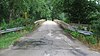 | 1907 | 1981-11-30 | Charleston 39°26′58″N 88°9′1″W / 39.44944°N 88.15028°W / 39.44944; -88.15028 (Blakeman Bridge) | Coles | triple arch, concrete |
| Bolivia Road Bridge |  | 1901 | 2004-01-28 | Bolivia 39°46′9″N 89°20′44″W / 39.76917°N 89.34556°W / 39.76917; -89.34556 (Bolivia Road Bridge) | Sangamon | Parker Through Truss |
| Bridge at Thirteenth Street | 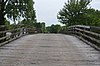 | 2016-04-26 | St. Francisville 38°35′34.5″N 87°39′12″W / 38.592917°N 87.65333°W / 38.592917; -87.65333 (Bridge at Thirteenth Street) | Lawrence | ||
| Buckeye Bridge |  | 1910 | 1980-10-29 | Smithfield 40°31′54″N 90°18′40″W / 40.53167°N 90.31111°W / 40.53167; -90.31111 (Buckeye Bridge) | Fulton | Parker |
| Camelback Bridge |  | 1997-05-15 | Normal 40°29′53.5″N 88°59′1″W / 40.498194°N 88.98361°W / 40.498194; -88.98361 (Camelback Bridge) | McLean | King post | |
| Cemetery Road Bridge | 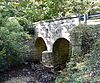 | 1894 | 1998-05-20 | Washington 40°41′51″N 89°24′41″W / 40.69750°N 89.41139°W / 40.69750; -89.41139 (Cemetery Road Bridge) | Tazewell | Stone double arch bridge |
| Chain of Rocks Bridge |  | 1929, 1936 | 2006-12-01 | Madison | Madison | Warren Truss |
| Chicago & North Western Railway Stone Arch Bridge |  | 1882 | 1993-08-19 | Roscoe 42°24′57″N 88°59′51″W / 42.41583°N 88.99750°W / 42.41583; -88.99750 (Chicago & North Western Railway Stone Arch Bridge) | Winnebago | Stone arch bridge |
| Duncan Mills Bridge | ca. 1910 | 1980-10-29 | Lewistown | Fulton | Parker | |
| Eads Bridge | 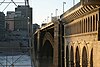 | 1867, 1874 | 1966-10-15 | East St. Louis 38°37′45″N 90°11′8″W / 38.62917°N 90.18556°W / 38.62917; -90.18556 (Eads Bridge) | St. Clair | Cantilever deck arch |
| Embarras River Bridge | 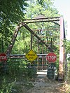 | 1890 | 1998-05-20 | Newton 38°59′43″N 88°9′43″W / 38.99528°N 88.16194°W / 38.99528; -88.16194 (Embarras River Bridge) | Jasper | Pratt through truss |
| Fall Creek Stone Arch Bridge |  | 1855 | 1996-11-07 | Payson 39°47′6″N 91°18′8″W / 39.78500°N 91.30222°W / 39.78500; -91.30222 (Fall Creek Stone Arch Bridge) | Adams | stone arch bridge |
| Fountain Creek Bridge | 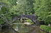 | 1849 | 1978-12-22 | Waterloo 38°19′33″N 90°11′45″W / 38.32583°N 90.19583°W / 38.32583; -90.19583 (Fountain Creek Bridge) | Monroe | |
| General Dean Suspension Bridge |  | 1859 | 1973-04-03 | Carlyle 38°36′40″N 89°21′26″W / 38.61111°N 89.35722°W / 38.61111; -89.35722 (General Dean Suspension Bridge) | Clinton | |
| Harrison Street Bridge | 1898 | 1981-11-30 | Charleston 39°29′8″N 88°6′57″W / 39.48556°N 88.11583°W / 39.48556; -88.11583 (Harrison Street Bridge) | Coles | Camelback Parker truss | |
| Hazen Bridge |  | 1893 | 1994-05-06 | Mahomet 40°15′9″N 88°23′1″W / 40.25250°N 88.38361°W / 40.25250; -88.38361 (Hazen Bridge) | Champaign | Pratt through truss |
| Illinois Central Stone Arch Railroad Bridges | 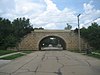 | 1852, 1855 | 1987-12-02 | Dixon | Lee | |
| Indian Ford Bridge | 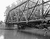 | ca. 1917 | 1980-10-29 | London Mills 40°41′25″N 90°17′24″W / 40.69028°N 90.29000°W / 40.69028; -90.29000 (Indian Ford Bridge) | Fulton | Pratt |
| London Mills Bridge | 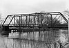 | 1883 | 1980-10-29 | London Mills 40°42′36″N 90°16′0″W / 40.71000°N 90.26667°W / 40.71000; -90.26667 (London Mills Bridge) | Fulton | Pratt |
| Lyndon Bridge |  | 1894, 1912 | 2003-05-09 | Lyndon 41°42′40″N 89°55′27″W / 41.71111°N 89.92417°W / 41.71111; -89.92417 (Lyndon Bridge) | Whiteside | Parker Pratt through truss |
| Mary's River Covered Bridge |  | 1854 | 1974-12-31 | Chester 37°56′55″N 89°45′57″W / 37.94861°N 89.76583°W / 37.94861; -89.76583 (Mary's River Covered Bridge) | Randolph | Burr Arch design |
| Ninth Street Seven Arch Stone Bridge | 1868, 1869, 1902 | 2004-08-20 | Lockport 41°35′36″N 88°3′53″W / 41.59333°N 88.06472°W / 41.59333; -88.06472 (Ninth Street Seven Arch Stone Bridge) | Will | Stone Arch Bridge | |
| Old Stone Arch Bridge | ca. 1832 | 1978-11-28 | Clark Center 39°22′13″N 87°45′29″W / 39.37028°N 87.75806°W / 39.37028; -87.75806 (Old Stone Arch Bridge) | Clark | ||
| Old Stone Arch, National Road |  | 1975-02-20 | Marshall 39°23′13″N 87°42′30″W / 39.38694°N 87.70833°W / 39.38694; -87.70833 (Old Stone Arch, National Road) | Clark | ||
| Oquawka Wagon Bridge | 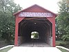 | 1866 | 1975-02-24 | Oquawka | Henderson | Burr Arch Truss |
| Red Covered Bridge |  | 1863 | 1975-04-23 | Princeton 41°24′59″N 89°28′43″W / 41.41639°N 89.47861°W / 41.41639; -89.47861 (Red Covered Bridge) | Bureau | |
| Savanna-Sabula Bridge |  | 1931 | 1999-08-27 | Savanna 42°6′14″N 90°10′1″W / 42.10389°N 90.16694°W / 42.10389; -90.16694 (Savanna-Sabula Bridge) | Carroll | Cantilever through truss |
| Seville Bridge | 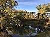 | ca. 1880 | 1980-10-29 | Seville | Fulton | Parker |
| Sixth, Seventh, and Tenth Street Stone Arch Bridges |  | 2001-08-08 | Charleston | Coles | Stone arch bridge | |
| Stone Arch Bridge |  | 1860 | 1981-05-14 | Champaign 40°6′46″N 88°14′14″W / 40.11278°N 88.23722°W / 40.11278; -88.23722 (Stone Arch Bridge) | Champaign | |
| Stone Arch Bridge |  | 1895, 1896 | 1986-05-16 | Danville 40°7′28″N 87°37′4″W / 40.12444°N 87.61778°W / 40.12444; -87.61778 (Stone Arch Bridge) | Jersey | Segmental Arch |
| Stone Quarry Bridge |  | 1883 | 1981-11-30 | Charleston 39°30′47″N 88°6′57″W / 39.51306°N 88.11583°W / 39.51306; -88.11583 (Stone Quarry Bridge) | Coles | double intersection Pratt |
| Sugar Creek Covered Bridge | 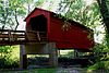 | 1827 | 1978-01-09 | Chatham 39°38′25″N 89°39′43″W / 39.64028°N 89.66194°W / 39.64028; -89.66194 (Sugar Creek Covered Bridge) | Sangamon | Wooden-trussed bridge |
| Sylvan Road Bridge |  | 1915 | 1978-06-23 | Glencoe 42°8′40″N 87°45′48″W / 42.14444°N 87.76333°W / 42.14444; -87.76333 (Sylvan Road Bridge) | Cook | Frank Lloyd Wright's only bridge |
| Tartar's Ferry Bridge |  | ca. 1880 | 1980-10-29 | Smithfield | Fulton | Parker |
| Third Street Bridge (Delavan, Illinois) |  | 1907 | 1999-05-20 | Delavan 40°22′24.6″N 89°32′40.5″W / 40.373500°N 89.544583°W / 40.373500; -89.544583 (Third Street Bridge) | Tazewell | Double int. Warren Double Po |
| Thompson Mill Covered Bridge |  | 1868 | 1975-03-13 | Cowden 39°15′30″N 88°49′5″W / 39.25833°N 88.81806°W / 39.25833; -88.81806 (Thompson Mill Covered Bridge) | Shelby | |
| Waltmire Bridge |  | 1910 | 1999-02-05 | Tremont 40°26′57.4″N 89°29′31″W / 40.449278°N 89.49194°W / 40.449278; -89.49194 (Waltmire Bridge) | Tazewell | Pratt Through Truss |
| Elrod Bridge | ca. 1890 | removed 1995-12-08 | Smithfield | Fulton | ||
| Wolf Covered Bridge | 1848, 1874 | removed 1995-12-08 | Yates City 40°51′24″N 90°6′36″W / 40.85667°N 90.11000°W / 40.85667; -90.11000 (Wolf Covered Bridge) | Knox | Pratt truss |
Notes
Map all coordinates using OpenStreetMap
Download coordinates as:
- KML
- GPX (all coordinates)
- GPX (primary coordinates)
- GPX (secondary coordinates)
- ^ a b "National Register Information System". National Register of Historic Places. National Park Service. July 9, 2010.
- v
- t
- e
- Alabama
- Alaska
- Arizona
- Arkansas
- California
- Colorado
- Connecticut
- Delaware
- Florida
- Georgia
- Guam
- Hawaii
- Idaho
- Illinois
- Indiana
- Iowa
- Kansas
- Kentucky
- Louisiana
- Maine
- Maryland
- Massachusetts
- Michigan
- Minnesota
- Mississippi
- Missouri
- Montana
- Nebraska
- Nevada
- New Hampshire
- New Jersey
- New Mexico
- New York
- North Carolina
- North Dakota
- Ohio
- Oklahoma
- Oregon
- Pennsylvania
- Puerto Rico
- Rhode Island
- South Carolina
- South Dakota
- Tennessee
- Texas
- Utah
- Vermont
- Virginia
- Washington
- Washington, D.C.
- West Virginia
- Wisconsin
- Wyoming


