Petre Bay
Bay along the west coast of Chatham Island, New Zealand

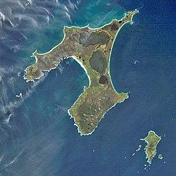
Petre Bay is a large bay which comprises about half of the west coast of Chatham Island, the largest island in New Zealand's Chatham Islands archipelago. It is some 20 kilometres (12 mi) in extent, and contains the far smaller Waitangi Bay, where the island group's largest settlement, Waitangi is located.
The bay is named after Lord Petre, a director of the New Zealand Company.[1]
References
- ^ New Zealand Geographic Board, "Petre Bay", New Zealand Gazetteer, Land Information New Zealand, archived from the original on 12 July 2023, retrieved 7 February 2024
- v
- t
- e
Chatham Islands
- Castle
- Chatham
- Forty-Fours
- Little Mangere
- Mangere
- North-East Reef
- Pitt
- Pyramid
- Rabbit
- Round Rock
- Sail Rock
- Sisters
- South East
- Star Keys
- Sugar Loaf

- Motuhope
- Motuhara/Motchuhar
- Rangatira
- Rangiauria
- Rangitatahi
- Rangituka
- Rangiwheau
- Rekohu/Wharekauri
- Tapuaenuku
- Tarakoikoia
- Terangi-Taumaewa
43°52′S 176°33′W / 43.867°S 176.550°W / -43.867; -176.550
 | This article about the geography of New Zealand's outlying islands is a stub. You can help Wikipedia by expanding it. |
- v
- t
- e


