National Register of Historic Places listings in Palm Beach County, Florida

This is a list of the National Register of Historic Places listings in Palm Beach County, Florida.
This is intended to be a complete list of the properties and districts on the National Register of Historic Places in Palm Beach County, Florida, United States. The locations of National Register properties and districts for which the latitude and longitude coordinates are included below, may be seen in a map.[1]
There are 75 properties and districts listed on the National Register in the county, including 2 National Historic Landmarks. Another 5 properties were once listed on the Register but have been removed.
This National Park Service list is complete through NPS recent listings posted June 7, 2024.[2]
Map all coordinates using OpenStreetMap
Download coordinates as:
- KML
- GPX (all coordinates)
- GPX (primary coordinates)
- GPX (secondary coordinates)
| Alachua - Baker - Bay - Bradford - Brevard - Broward - Calhoun - Charlotte - Citrus - Clay - Collier - Columbia - DeSoto - Dixie - Duval - Escambia - Flagler - Franklin - Gadsden - Gilchrist - Glades - Gulf - Hamilton - Hardee - Hendry - Hernando - Highlands - Hillsborough (Tampa) - Holmes - Indian River - Jackson - Jefferson - Lafayette - Lake - Lee - Leon - Levy - Liberty - Madison - Manatee - Marion - Martin - Miami-Dade (Miami) - Monroe - Nassau - Okaloosa - Okeechobee - Orange - Osceola - Palm Beach - Pasco - Pinellas - Polk - Putnam - St. Johns - St. Lucie - Santa Rosa - Sarasota - Seminole - Sumter - Suwannee - Taylor - Union - Volusia - Wakulla - Walton - Washington |
Current listings
| [3] | Name on the Register[4] | Image | Date listed[5] | Location | City or town | Description |
|---|---|---|---|---|---|---|
| 1 | Administration Buildings |  | June 27, 1985 (#85001372) | Dixie Highway and Camino Real 26°20′24″N 80°05′22″W / 26.34°N 80.089444°W / 26.34; -80.089444 (Administration Buildings) | Boca Raton | Built by Addison Mizner. |
| 2 | Fred C. Aiken House | 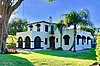 | September 24, 1992 (#92001271) | 801 Hibiscus Street 26°21′10″N 80°06′10″W / 26.352778°N 80.102778°W / 26.352778; -80.102778 (Fred C. Aiken House) | Boca Raton | |
| 3 | American National Bank Building | 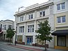 | October 8, 1997 (#97001217) | 114 South Olive Avenue 26°42′42″N 80°03′12″W / 26.711667°N 80.053333°W / 26.711667; -80.053333 (American National Bank Building) | West Palm Beach | |
| 4 | Old Belle Glade Town Hall |  | October 8, 2014 (#14000827) | 33 W. Ave. A 26°41′10″N 80°40′08″W / 26.686163°N 80.668906°W / 26.686163; -80.668906 (Old Belle Glade Town Hall) | Belle Glade | |
| 5 | Big Mound City | Upload image | May 24, 1973 (#73000596) | Address Restricted | Canal Point | |
| 6 | Boca Raton Fire Engine No. 1 |  | November 1, 2001 (#01001195) | 100 South Ocean Boulevard 26°20′59″N 80°04′13″W / 26.349722°N 80.070278°W / 26.349722; -80.070278 (Boca Raton Fire Engine No. 1) | Boca Raton | |
| 7 | Boca Raton Old City Hall |  | October 16, 1980 (#80000958) | 71 North Federal Highway 26°21′03″N 80°05′13″W / 26.350833°N 80.086944°W / 26.350833; -80.086944 (Boca Raton Old City Hall) | Boca Raton | Houses Boca Raton History Museum and Welcome Center. Original design by Addison Mizner. |
| 8 | Boynton School | 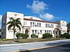 | March 7, 1994 (#94000139) | 141 East Ocean Avenue 26°31′38″N 80°03′48″W / 26.527222°N 80.063333°W / 26.527222; -80.063333 (Boynton School) | Boynton Beach | |
| 9 | Boynton Woman's Club |  | April 26, 1979 (#79000686) | 1010 South Federal Highway 26°31′07″N 80°03′30″W / 26.518611°N 80.058333°W / 26.518611; -80.058333 (Boynton Woman's Club) | Boynton Beach | |
| 10 | Breakers Hotel Complex | 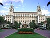 | August 14, 1973 (#73000598) | South County Road 26°42′54″N 80°02′02″W / 26.714909°N 80.03388°W / 26.714909; -80.03388 (Breakers Hotel Complex) | Palm Beach | |
| 11 | Central Park Historic District |  | July 28, 1999 (#99000898) | Roughly along State Road 805 and South Olive Avenue from Monroe Drive to Southern Boulevard 26°40′37″N 80°03′06″W / 26.676944°N 80.051667°W / 26.676944; -80.051667 (Central Park Historic District) | West Palm Beach | |
| 12 | Clematis Street Historic Commercial District | 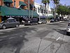 | October 8, 1998 (#98001230) | 500 block of Clematis Street 26°42′47″N 80°03′22″W / 26.713056°N 80.056111°W / 26.713056; -80.056111 (Clematis Street Historic Commercial District) | West Palm Beach | |
| 13 | College Park Historic District | 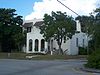 | February 9, 2001 (#01000078) | Roughly bounded by Maryland Drive, North Federal Highway, 19th Avenue North, and North Dixie Highway 26°38′24″N 80°03′17″W / 26.64°N 80.054722°W / 26.64; -80.054722 (College Park Historic District) | Lake Worth | |
| 14 | Comeau Building |  | September 6, 1996 (#96000975) | 319 Clematis Street 26°42′48″N 80°03′09″W / 26.713333°N 80.0525°W / 26.713333; -80.0525 (Comeau Building) | West Palm Beach | |
| 15 | Alfred J. Comeau House |  | March 24, 2000 (#00000238) | 701 Flamingo Drive 26°41′46″N 80°03′32″W / 26.696111°N 80.058889°W / 26.696111; -80.058889 (Alfred J. Comeau House) | West Palm Beach | |
| 16 | Delray Beach Schools | 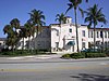 | March 10, 1988 (#88000210) | Block 68 26°27′45″N 80°04′21″W / 26.4625°N 80.0725°W / 26.4625; -80.0725 (Delray Beach Schools) | Delray Beach | |
| 17 | Eastover |  | December 23, 2002 (#02001694) | 1100 South Ocean Boulevard 26°34′13″N 80°02′25″W / 26.570278°N 80.040278°W / 26.570278; -80.040278 (Eastover) | Manalapan | |
| 18 | El Cid Historic District |  | August 31, 1995 (#95001064) | Roughly bounded by Flamingo Drive, South Flagler Drive, Dyer Road, and South Dixie Highway 26°41′31″N 80°03′05″W / 26.691944°N 80.051389°W / 26.691944; -80.051389 (El Cid Historic District) | West Palm Beach | |
| 19 | J. B. Evans House |  | March 28, 2002 (#02000265) | 142 South Ocean Boulevard 26°27′29″N 80°03′35″W / 26.458056°N 80.059722°W / 26.458056; -80.059722 (J. B. Evans House) | Delray Beach | |
| 20 | Ferndix Building |  | July 22, 1999 (#99000861) | 401 Fern Street 26°42′38″N 80°03′15″W / 26.710556°N 80.054167°W / 26.710556; -80.054167 (Ferndix Building) | West Palm Beach | |
| 21 | Henry Morrison Flagler House: Whitehall |  | December 5, 1972 (#72000345) | Whitehall Way 26°42′49″N 80°02′38″W / 26.713611°N 80.043889°W / 26.713611; -80.043889 (Henry Morrison Flagler House: Whitehall) | Palm Beach | |
| 22 | Flamingo Park Historic Residential District |  | July 14, 2000 (#00000785) | Roughly bounded by Park Place, Parker Avenue, Belvedere Road, and Florida Avenue 26°41′33″N 80°03′38″W / 26.6925°N 80.060556°W / 26.6925; -80.060556 (Flamingo Park Historic Residential District) | West Palm Beach | |
| 23 | Florida East Coast Railway Passenger Station |  | October 24, 1980 (#80000959) | Off State Road 808 26°20′33″N 80°05′21″W / 26.3425°N 80.089167°W / 26.3425; -80.089167 (Florida East Coast Railway Passenger Station) | Boca Raton | Houses Boca Express Train Museum. |
| 24 | Grandview Heights Historic District | 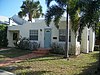 | July 8, 1999 (#99000795) | Roughly bounded by Park Place, Alabama Avenue, M Street, and South Lake Avenue 26°42′00″N 80°03′29″W / 26.7°N 80.058056°W / 26.7; -80.058056 (Grandview Heights Historic District) | West Palm Beach | |
| 25 | Guaranty Building |  | December 10, 1998 (#98001483) | 120 South Olive Avenue 26°42′44″N 80°03′04″W / 26.712222°N 80.051111°W / 26.712222; -80.051111 (Guaranty Building) | West Palm Beach | |
| 26 | Gulf Stream Hotel | 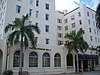 | January 11, 1983 (#83001435) | 1 Lake Avenue 26°36′55″N 80°02′56″W / 26.615278°N 80.048889°W / 26.615278; -80.048889 (Gulf Stream Hotel) | Lake Worth | |
| 27 | Hatch's Department Store |  | April 14, 1994 (#94000348) | 301-307 Clematis Street 26°42′49″N 80°03′08″W / 26.713611°N 80.052222°W / 26.713611; -80.052222 (Hatch's Department Store) | West Palm Beach | |
| 28 | Historic Old Town Commercial District |  | September 22, 2001 (#01001011) | Bounded by FEC, M Street, Lucerne Avenue, and 1st Avenue S 26°36′56″N 80°03′11″W / 26.615529°N 80.052924°W / 26.615529; -80.052924 (Historic Old Town Commercial District) | Lake Worth | |
| 29 | House at 1240 Cocoanut Road |  | August 17, 2001 (#01000888) | 1240 Cocoanut Road 26°19′56″N 80°04′36″W / 26.332222°N 80.076667°W / 26.332222; -80.076667 (House at 1240 Cocoanut Road) | Boca Raton | |
| 30 | Hurricane of 1928 African American Mass Burial Site |  | September 12, 2002 (#02001012) | Junction of 25th Street and Tamarind Avenue 26°44′09″N 80°03′42″W / 26.735833°N 80.061667°W / 26.735833; -80.061667 (Hurricane of 1928 African American Mass Burial Site) | West Palm Beach | |
| 31 | Jupiter Inlet Historic and Archeological Site | 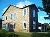 | November 5, 1985 (#85003486) | Address Restricted | Jupiter | |
| 32 | Jupiter Inlet Lighthouse | 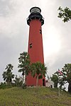 | October 15, 1973 (#73000597) | Junction of the Loxahatchee River and Jupiter Sound 26°56′50″N 80°04′47″W / 26.947222°N 80.079722°W / 26.947222; -80.079722 (Jupiter Inlet Lighthouse) | Jupiter | |
| 33 | Kelsey City City Hall | 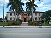 | September 3, 1981 (#81000195) | 535 Park Avenue 26°47′57″N 80°04′17″W / 26.799167°N 80.071389°W / 26.799167; -80.071389 (Kelsey City City Hall) | Lake Park | |
| 34 | Lavender House |  | February 24, 1995 (#95000165) | 875 Alamanda Street 26°21′04″N 80°06′15″W / 26.351111°N 80.104167°W / 26.351111; -80.104167 (Lavender House) | Boca Raton | |
| 35 | Lofthus (shipwreck) |  | January 6, 2004 (#03001363) | ¾ mile north of Boynton Inlet, 175 yards offshore 26°33′47″N 80°02′23″W / 26.563056°N 80.039722°W / 26.563056; -80.039722 (Lofthus (shipwreck)) | Boynton Beach | |
| 36 | Loxahatchee Battlefield |  | April 5, 2024 (#100007672) | 9060 Indiantown Rd. 26°55′52″N 80°10′37″W / 26.931072°N 80.176907°W / 26.931072; -80.176907 (Loxahatchee Battlefield) | Jupiter | |
| 37 | Mango Promenade Historic District |  | July 8, 1999 (#99000801) | Roughly bounded by South Dixie Highway, Austin Lane, Coconut Lane, and Cranesnest Way 26°41′51″N 80°03′12″W / 26.6975°N 80.053333°W / 26.6975; -80.053333 (Mango Promenade Historic District) | West Palm Beach | |
| 38 | Mar-a-Lago National Historic Landmark | 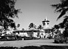 | December 23, 1980 (#80000961) | 1100 South Ocean Boulevard 26°40′40″N 80°02′10″W / 26.677778°N 80.036111°W / 26.677778; -80.036111 (Mar-a-Lago National Historic Landmark) | Palm Beach | |
| 39 | Marina Historic District |  | June 2, 2014 (#14000268) | Bounded by E. Atlantic Ave., Marine Way, SE 4th Str, SE 7th Ave. 26°27′30″N 80°03′56″W / 26.4583109°N 80.065674°W / 26.4583109; -80.065674 (Marina Historic District) | Delray Beach | |
| 40 | Mickens House |  | April 11, 1985 (#85000769) | 801 4th Street 26°43′02″N 80°03′36″W / 26.717222°N 80.06°W / 26.717222; -80.06 (Mickens House) | West Palm Beach | |
| 41 | Milton-Myers American Legion Post No. 65 | 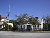 | April 20, 1995 (#95000471) | 263 Northeast 5th Avenue 26°27′57″N 80°04′05″W / 26.465833°N 80.068056°W / 26.465833; -80.068056 (Milton-Myers American Legion Post No. 65) | Delray Beach | |
| 42 | Northboro Park Historic District | 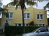 | February 20, 2007 (#07000059) | Bounded by 40th N., Flagler Drive, 36th Street, and Broadway 26°44′51″N 80°03′16″W / 26.7475°N 80.054444°W / 26.7475; -80.054444 (Northboro Park Historic District) | West Palm Beach | |
| 43 | Northwest Historic District | 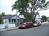 | January 22, 1992 (#91002005) | Roughly bounded by Tamarind Avenue, Eleventh Street, Rosemary Avenue, and Third Street 26°43′09″N 80°03′34″W / 26.719167°N 80.059444°W / 26.719167; -80.059444 (Northwest Historic District) | West Palm Beach | |
| 44 | Norton House | 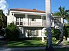 | July 26, 1990 (#90001106) | 253 Barcelona Road 26°41′42″N 80°03′03″W / 26.695°N 80.050833°W / 26.695; -80.050833 (Norton House) | West Palm Beach | |
| 45 | Old Lake Worth City Hall |  | May 18, 1989 (#89000432) | 414 Lake Avenue 26°36′57″N 80°03′18″W / 26.615833°N 80.055°W / 26.615833; -80.055 (Old Lake Worth City Hall) | Lake Worth | |
| 46 | Old Northwood Historic District | 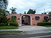 | April 14, 1994 (#94000368) | Roughly bounded by Broadway, North Dixie Highway, and 26th and 35th Streets 26°44′28″N 80°03′17″W / 26.741111°N 80.054722°W / 26.741111; -80.054722 (Old Northwood Historic District) | West Palm Beach | |
| 47 | Old Lucerne Historic Residential District |  | June 4, 2001 (#01000526) | Roughly along North Lakeside Drive, North Palmway Street, and North O Street, from Lake Avenue to 7th Avenue, N. 26°37′10″N 80°03′04″W / 26.619444°N 80.051111°W / 26.619444; -80.051111 (Old Lucerne Historic Residential District) | Lake Worth | |
| 48 | Old Palm Beach Junior College Building | 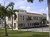 | May 30, 1991 (#91000601) | 813 Gardenia Avenue 26°42′34″N 80°03′38″W / 26.709444°N 80.060556°W / 26.709444; -80.060556 (Old Palm Beach Junior College Building) | West Palm Beach | |
| 49 | Old School Square Historic District | | March 14, 2018 (#100002095) | Bounded by Lake Ida Rd. NE 1st Ave., SW 2nd St. & N Swinton Ave. 26°27′48″N 80°04′21″W / 26.463444°N 80.072574°W / 26.463444; -80.072574 (Old School Square Historic District) | Delray Beach | |
| 50 | Old West Palm Beach National Guard Armory |  | June 11, 1992 (#92000142) | 1703 South Lake Avenue 26°41′53″N 80°03′41″W / 26.698056°N 80.061389°W / 26.698056; -80.061389 (Old West Palm Beach National Guard Armory) | West Palm Beach | |
| 51 | Osborne School |  | August 1, 2003 (#03000701) | 1718 South Douglas Street 26°35′39″N 80°03′22″W / 26.594167°N 80.056111°W / 26.594167; -80.056111 (Osborne School) | Lake Worth | Part of the Florida's Historic Black Public Schools MPS |
| 52 | Pahokee High School |  | November 15, 1996 (#96001334) | 360 Main Street 26°49′30″N 80°39′48″W / 26.825°N 80.663333°W / 26.825; -80.663333 (Pahokee High School) | Pahokee | |
| 53 | Palm Beach Daily News Building |  | December 24, 1985 (#85003121) | 204 Brazilian Avenue 26°42′13″N 80°02′13″W / 26.703611°N 80.036944°W / 26.703611; -80.036944 (Palm Beach Daily News Building) | Palm Beach | |
| 54 | Palm Beach Hotel |  | April 21, 2010 (#10000212) | 235-251 Sunrise Ave. 26°43′13″N 80°02′23″W / 26.720278°N 80.039722°W / 26.720278; -80.039722 (Palm Beach Hotel) | Palm Beach | |
| 55 | Palm Beach Mercantile Company | 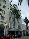 | January 28, 1994 (#93001552) | 206 Clematis Street 26°42′46″N 80°03′08″W / 26.712778°N 80.052222°W / 26.712778; -80.052222 (Palm Beach Mercantile Company) | West Palm Beach | |
| 56 | Palm Beach Town Hall | 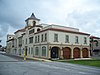 | January 28, 2005 (#04001571) | 360 South County Road 26°42′09″N 80°02′12″W / 26.7025°N 80.036667°W / 26.7025; -80.036667 (Palm Beach Town Hall) | Palm Beach | |
| 57 | Paramount Theatre Building |  | December 12, 1973 (#73000599) | 145 North County Road 26°43′09″N 80°02′14″W / 26.719167°N 80.037222°W / 26.719167; -80.037222 (Paramount Theatre Building) | Palm Beach | |
| 58 | Pearl City National Register Historic District | Upload image | December 7, 2023 (#100009609) | Bounded by NE 15th Terr., N. Federal Hwy, NE 10th St & N Dixie Hwy 26°21′44″N 80°05′01″W / 26.362325°N 80.083638°W / 26.362325; -80.083638 (Pearl City National Register Historic District) | Boca Raton | |
| 59 | Pine Ridge Hospital |  | January 26, 2001 (#00001675) | 1401 Division Avenue 26°43′31″N 80°03′39″W / 26.725278°N 80.060833°W / 26.725278; -80.060833 (Pine Ridge Hospital) | West Palm Beach | |
| 60 | Professional Building | 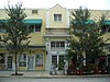 | October 24, 1996 (#96001187) | 310 South Dixie Highway 26°42′39″N 80°03′13″W / 26.710833°N 80.053611°W / 26.710833; -80.053611 (Professional Building) | West Palm Beach | |
| 61 | Prospect Park-Southland Park Historic District |  | April 8, 2011 (#11000181) | Bounded by Lake Worth, S Dixie HWY, Monceaux Rd, Monroe Dr, 26°41′03″N 80°03′05″W / 26.684167°N 80.051389°W / 26.684167; -80.051389 (Prospect Park-Southland Park Historic District) | West Palm Beach | |
| 62 | Clifton Rice House |  | April 26, 1996 (#96000466) | 714 Claremore Drive 26°41′40″N 80°03′34″W / 26.694444°N 80.059444°W / 26.694444; -80.059444 (Clifton Rice House) | West Palm Beach | |
| 63 | Royal Poinciana Way Historic District | 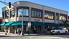 | September 17, 2015 (#15000588) | Bounded by 207-283 Royal Poinciana Way, 95-118 N. Cty. Rd. 184-280 26°43′06″N 80°02′22″W / 26.718438°N 80.039452°W / 26.718438; -80.039452 (Royal Poinciana Way Historic District) | Palm Beach | |
| 64 | Seaboard Air Line Dining Car-6113 |  | April 5, 2001 (#01000334) | 747 South Dixie Highway 26°20′32″N 80°05′22″W / 26.342222°N 80.089444°W / 26.342222; -80.089444 (Seaboard Air Line Dining Car-6113) | Boca Raton | Florida's Historic Railroad Resources MPS |
| 65 | Seaboard Air Line Lounge Car-6603 |  | April 5, 2001 (#01000335) | 747 South Dixie Highway 26°20′32″N 80°05′22″W / 26.342222°N 80.089444°W / 26.342222; -80.089444 (Seaboard Air Line Lounge Car-6603) | Boca Raton | Florida's Historic Railroad Resources MPS |
| 66 | Seaboard Airline Railroad Station |  | September 4, 1986 (#86002172) | 1525 West Atlantic Avenue 26°27′49″N 80°05′27″W / 26.463611°N 80.090833°W / 26.463611; -80.090833 (Seaboard Airline Railroad Station) | Delray Beach | |
| 67 | Seaboard Coastline Railroad Passenger Station | 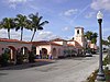 | June 19, 1973 (#73000600) | Tamarind Avenue at Datura Street 26°42′44″N 80°03′44″W / 26.712222°N 80.062222°W / 26.712222; -80.062222 (Seaboard Coastline Railroad Passenger Station) | West Palm Beach | |
| 68 | John and Elizabeth Shaw Sundy House |  | January 16, 1992 (#91001910) | 106 South Swinton Avenue 26°27′33″N 80°04′25″W / 26.459167°N 80.073611°W / 26.459167; -80.073611 (John and Elizabeth Shaw Sundy House) | Delray Beach | |
| 69 | US Post Office | 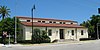 | July 21, 1983 (#83001436) | 95 North County Road 26°43′05″N 80°02′18″W / 26.718056°N 80.038333°W / 26.718056; -80.038333 (US Post Office) | Palm Beach | |
| 70 | Grant Van Valkenburg House |  | August 2, 1999 (#99000860) | 213 Rosemary Avenue 26°42′41″N 80°03′26″W / 26.711389°N 80.057222°W / 26.711389; -80.057222 (Grant Van Valkenburg House) | West Palm Beach | |
| 71 | Vedado Historic District |  | October 15, 2010 (#10000821) | Roughly bounded Merril Ave, Southern Blvd, Parker Ave & Paseo Morella 26°40′39″N 80°03′54″W / 26.6775°N 80.065°W / 26.6775; -80.065 (Vedado Historic District) | West Palm Beach | |
| 72 | Via Mizner |  | April 1, 1993 (#93000256) | 337-339 Worth Avenue 26°42′04″N 80°02′26″W / 26.701111°N 80.040556°W / 26.701111; -80.040556 (Via Mizner) | Palm Beach | |
| 73 | Vineta Hotel |  | August 21, 1986 (#86001724) | 363 Cocoanut Row 26°42′10″N 80°02′28″W / 26.702778°N 80.041111°W / 26.702778; -80.041111 (Vineta Hotel) | Palm Beach | |
| 74 | William Gray Warden House | 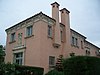 | August 1, 1984 (#84000940) | 112 Seminole Avenue 26°43′17″N 80°02′08″W / 26.721389°N 80.035556°W / 26.721389; -80.035556 (William Gray Warden House) | Palm Beach | |
| 75 | West Palm Beach Fishing Club |  | June 13, 2016 (#16000360) | 201 5th St. 26°43′05″N 80°03′03″W / 26.718001°N 80.050696°W / 26.718001; -80.050696 (West Palm Beach Fishing Club) | West Palm Beach |
Former listings
| [3] | Name on the Register | Image | Date listed | Date removed | Location | City or town | Description |
|---|---|---|---|---|---|---|---|
| 1 | Bingham-Blossom House |  | December 5, 1972 (#72000344) | January 4, 2012 | 1250 South Ocean Boulevard 26°40′19″N 80°02′28″W / 26.671944°N 80.041111°W / 26.671944; -80.041111 (Bingham-Blossom House) | Palm Beach | Demolished in 1984.[6] |
| 2 | Brelsford House |  | May 3, 1974 (#74000653) | January 4, 2012 | 1 Lake Trail 26°42′35″N 80°02′16″W / 26.709722°N 80.037778°W / 26.709722; -80.037778 (Brelsford House) | Palm Beach | Demolished in August 1975[7] |
| 3 | Dixie Court Hotel |  | August 21, 1986 (#86001723) | January 4, 2012 | 301 North Dixie Highway 26°43′10″N 80°03′13″W / 26.719444°N 80.053611°W / 26.719444; -80.053611 (Dixie Court Hotel) | West Palm Beach | Demolished in 1990.[8] |
| 4 | Hibiscus Apartments |  | May 10, 1984 (#84000935) | January 4, 2012 | 619 Hibiscus Street 26°42′31″N 80°03′30″W / 26.708611°N 80.058333°W / 26.708611; -80.058333 (Hibiscus Apartments) | West Palm Beach | Destroyed by fire May 1, 1989.[9] Macy's built on site. |
| 5 | Palm Beach Winter Club | Upload image | August 1, 1980 (#80000960) | January 4, 2012 | U.S. Route 1 26°49′34″N 80°03′43″W / 26.826111°N 80.061944°W / 26.826111; -80.061944 (Palm Beach Winter Club) | North Palm Beach | Demolished in 1984.[10] |
See also
Wikimedia Commons has media related to National Register of Historic Places in Palm Beach County, Florida.
- History of Palm Beach County, Florida
- List of National Historic Landmarks in Florida
- National Register of Historic Places listings in Florida
References
- ^ The latitude and longitude information provided in this table was derived originally from the National Register Information System, which has been found to be fairly accurate for about 99% of listings. Some locations in this table may have been corrected to current GPS standards.
- ^ National Park Service, United States Department of the Interior, "National Register of Historic Places: Weekly List Actions", retrieved June 7, 2024.
- ^ a b Numbers represent an alphabetical ordering by significant words. Various colorings, defined here, differentiate National Historic Landmarks and historic districts from other NRHP buildings, structures, sites or objects.
- ^ "National Register Information System". National Register of Historic Places. National Park Service. March 13, 2009.
- ^ The eight-digit number below each date is the number assigned to each location in the National Register Information System database, which can be viewed by clicking the number.
- ^ Mayhew, Augustus (14 November 2010). "Unforgettable Palm Beach: Bingham family cultivated Figulus property, which produced Casa Apava, Blossom Estate". Palm Beach Daily News. Archived from the original on 18 July 2011. Retrieved 4 December 2010.
- ^ The Brelsford House, Historic American Buildings Survey data page, 1980. Accessed 2009-12-17.
- ^ Lowery, Fred. "Stately No More West Palm`s 64-year-old Dixie Court Hotel Is About To Be Torn Down To Make Room For A New Justice Center". SunSentinel.com. Retrieved 4 December 2010.
- ^ "Daily deomolitions sadden historians". The South Florida Sun Sentinel. May 10, 1989. p. 10B. Retrieved June 19, 2022 – via Newspapers.com.
- ^ "Registered Sites Reflect The Style Of Bygone Era". Sun Sentinel. 16 May 1985. Retrieved 15 April 2011., Carol Brzozowski and Carl Herzog
- v
- t
- e
by county
- Alachua
- Baker
- Bay
- Bradford
- Brevard
- Broward
- Calhoun
- Charlotte
- Citrus
- Clay
- Collier
- Columbia
- DeSoto
- Dixie
- Duval
- Escambia
- Flagler
- Franklin
- Gadsden
- Gilchrist
- Glades
- Gulf
- Hamilton
- Hardee
- Hendry
- Hernando
- Highlands
- Hillsborough
- Holmes
- Indian River
- Jackson
- Jefferson
- Lake
- Lee
- Leon
- Levy
- Liberty
- Madison
- Manatee
- Marion
- Martin
- Miami-Dade
- Monroe
- Nassau
- Okaloosa
- Okeechobee
- Orange
- Osceola
- Palm Beach
- Pasco
- Pinellas
- Polk
- Putnam
- Santa Rosa
- Sarasota
- Seminole
- St. Johns
- St. Lucie
- Sumter
- Suwannee
- Taylor
- Union
- Volusia
- Wakulla
- Walton
- Washington

Municipalities and communities of Palm Beach County, Florida, United States | ||
|---|---|---|
County seat: West Palm Beach | ||
| Cities |  | |
| Towns | ||
| Villages | ||
| CDPs | ||
| Former CDPs |
| |
| Unincorporated communities | ||
| Ghost towns | ||
| ||


