National Register of Historic Places listings in Jennings County, Indiana

This is a list of the National Register of Historic Places listings in Jennings County, Indiana.
This is intended to be a complete list of the properties and districts on the National Register of Historic Places in Jennings County, Indiana, United States. Latitude and longitude coordinates are provided for many National Register properties and districts; these locations may be seen together in a map.[1]
There are 10 properties and districts listed on the National Register in the county.
Properties and districts located in incorporated areas display the name of the municipality, while properties and districts in unincorporated areas display the name of their civil township. Properties and districts split between multiple jurisdictions display the names of all jurisdictions.
This National Park Service list is complete through NPS recent listings posted June 7, 2024.[2]
Map all coordinates using OpenStreetMap
Download coordinates as:
- KML
- GPX (all coordinates)
- GPX (primary coordinates)
- GPX (secondary coordinates)
Current listings
| [3] | Name on the Register[4] | Image | Date listed[5] | Location | City or town | Description |
|---|---|---|---|---|---|---|
| 1 | Annadale |  | January 25, 2007 (#06001292) | 502 S. Jennings St. 39°00′09″N 85°37′20″W / 39.002500°N 85.622222°W / 39.002500; -85.622222 (Annadale) | North Vernon | |
| 2 | Benville Bridge | Upload image | July 30, 1996 (#96000789) | US Army Jefferson Proving Ground, approximately 1 mile east off Perimeter Rd. 38°58′50″N 85°27′10″W / 38.980556°N 85.452778°W / 38.980556; -85.452778 (Benville Bridge) | Bigger Township | |
| 3 | Edward's Ford Bridge | Upload image | July 30, 1996 (#96000788) | US Army Jefferson Proving Ground, off Northwest Rd. 39°02′01″N 85°27′38″W / 39.033611°N 85.460556°W / 39.033611; -85.460556 (Edward's Ford Bridge) | Campbell Township | |
| 4 | Hicklin House and Settlement | Upload image | March 31, 2023 (#100008661) | 2330 South Cty. Rd. 675 East 38°56′45″N 85°29′20″W / 38.9457°N 85.4889°W / 38.9457; -85.4889 (Hicklin House and Settlement) | San Jacinto vicinity | |
| 5 | James Covered Bridge |  | August 24, 2022 (#100008061) | Cty. Rd. 650S over Graham Cr. approx. 1/2 mi. east of IN 3 38°53′34″N 85°36′56″W / 38.8929°N 85.6156°W / 38.8929; -85.6156 (James Covered Bridge) | Lovett Township | |
| 6 | North Vernon Downtown Historic District | 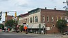 | April 19, 2006 (#06000306) | Bounded by 6th and Chestnut Sts., Keller St., 4th and Main, and Jennings 39°00′20″N 85°37′28″W / 39.005556°N 85.624444°W / 39.005556; -85.624444 (North Vernon Downtown Historic District) | North Vernon | |
| 7 | Scipio Covered Bridge |  | August 24, 2022 (#100008062) | Cty. Rd. 575W over Sand Cr. approx. 200 ft. southeast of Cty. Rd. 700N crossing point 39°05′05″N 85°43′13″W / 39.0846°N 85.7202°W / 39.0846; -85.7202 (Scipio Covered Bridge) | Scipio | |
| 8 | State Street Historic District | 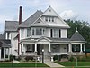 | January 25, 2007 (#06001290) | Roughly bounded by Chestnut, Jackson, Jefferson, and State Sts. 39°00′04″N 85°37′24″W / 39.001111°N 85.623333°W / 39.001111; -85.623333 (State Street Historic District) | North Vernon | |
| 9 | Vernon Historic District |  | August 27, 1976 (#76000024) | 1 mile south of North Vernon on State Roads State Road 3 and State Road 7 38°59′06″N 85°36′40″W / 38.985000°N 85.611111°W / 38.985000; -85.611111 (Vernon Historic District) | Vernon and Vernon Township | |
| 10 | Walnut Street Historic District |  | September 20, 2006 (#06000855) | Roughly including both sides of Walnut St. between State and Gum Sts. 39°00′11″N 85°37′38″W / 39.003056°N 85.627222°W / 39.003056; -85.627222 (Walnut Street Historic District) | North Vernon |
See also
Wikimedia Commons has media related to National Register of Historic Places in Jennings County, Indiana.
- List of National Historic Landmarks in Indiana
- National Register of Historic Places listings in Indiana
- Listings in neighboring counties: Bartholomew, Decatur, Jackson, Jefferson, Ripley, Scott
- List of Indiana state historical markers in Jennings County
References
- ^ The latitude and longitude information provided in this table was derived originally from the National Register Information System, which has been found to be fairly accurate for about 99% of listings. Some locations in this table may have been corrected to current GPS standards.
- ^ National Park Service, United States Department of the Interior, "National Register of Historic Places: Weekly List Actions", retrieved June 7, 2024.
- ^ Numbers represent an alphabetical ordering by significant words. Various colorings, defined here, differentiate National Historic Landmarks and historic districts from other NRHP buildings, structures, sites or objects.
- ^ "National Register Information System". National Register of Historic Places. National Park Service. March 13, 2009.
- ^ The eight-digit number below each date is the number assigned to each location in the National Register Information System database, which can be viewed by clicking the number.
- v
- t
- e
- List of U.S. National Historic Landmarks by state:
- Alabama
- Alaska
- Arizona
- Arkansas
- California
- Colorado
- Connecticut
- Delaware
- Florida
- Georgia
- Hawaii
- Idaho
- Illinois
- Indiana
- Iowa
- Kansas
- Kentucky
- Louisiana
- Maine
- Maryland
- Massachusetts
- Michigan
- Minnesota
- Mississippi
- Missouri
- Montana
- Nebraska
- Nevada
- New Hampshire
- New Jersey
- New Mexico
- New York
- North Carolina
- North Dakota
- Ohio
- Oklahoma
- Oregon
- Pennsylvania
- Rhode Island
- South Carolina
- South Dakota
- Tennessee
- Texas
- Utah
- Vermont
- Virginia
- Washington
- West Virginia
- Wisconsin
- Wyoming
 National Register of Historic Places portal
 Category


