National Register of Historic Places listings in Dallas County, Alabama

This is a list of the National Register of Historic Places listings in Dallas County, Alabama.
This is intended to be a complete list of the properties and districts on the National Register of Historic Places in Dallas County, Alabama, United States. Latitude and longitude coordinates are provided for many National Register properties and districts; these locations may be seen together in an online map.[1]
There are 35 properties and districts listed on the National Register in the county, including 2 National Historic Landmarks.
This National Park Service list is complete through NPS recent listings posted June 21, 2024.[2]
Map all coordinates using OpenStreetMap
Download coordinates as:
- KML
- GPX (all coordinates)
- GPX (primary coordinates)
- GPX (secondary coordinates)
Current listings
| [3] | Name on the Register | Image | Date listed[4] | Location | City or town | Description |
|---|---|---|---|---|---|---|
| 1 | Adams Grove Presbyterian Church |  | June 5, 1986 (#86001239) | Southern side of Cahaba-Greenville Rd. 32°16′20″N 87°01′51″W / 32.272222°N 87.030833°W / 32.272222; -87.030833 (Adams Grove Presbyterian Church) | Sardis | Wooden-framed Presbyterian church, built in the Greek Revival style in 1853. |
| 2 | Antique Store |  | January 29, 1987 (#86003662) | Off State Route 22 32°39′32″N 86°55′24″W / 32.659023°N 86.923292°W / 32.659023; -86.923292 (Antique Store) | Plantersville | |
| 3 | Brown Chapel African Methodist Episcopal Church |  | February 4, 1982 (#82002009) | 410 Martin Luther King, Jr. St. 32°24′45″N 87°00′58″W / 32.4125°N 87.016111°W / 32.4125; -87.016111 (Brown Chapel African Methodist Episcopal Church) | Selma | Brick African Methodist Episcopal church, built in 1908. Known for its association with the Civil Rights Movement and Selma to Montgomery marches. |
| 4 | Burwell-Dinkins-Anderson House | Upload image | June 17, 2022 (#100007801) | 700 L.L. Anderson Ave. 32°25′06″N 87°01′44″W / 32.4184°N 87.0289°W / 32.4184; -87.0289 (Burwell-Dinkins-Anderson House) | Selma | |
| 5 | Cahaba |  | May 8, 1973 (#73000341) | 11 miles (18 km) southwest of Selma at the junction of the Cahaba and Alabama Rivers 32°19′07″N 87°05′57″W / 32.318546°N 87.099266°W / 32.318546; -87.099266 (Cahaba) | Cahaba | First permanent state capital of Alabama (1820–1825); today a ghost town. |
| 6 | Carlowville Historic District |  | January 18, 1978 (#78000487) | 17 miles (27 km) south of Selma on State Route 89 32°05′15″N 87°02′01″W / 32.087392°N 87.033691°W / 32.087392; -87.033691 (Carlowville Historic District) | Carlowville | |
| 7 | Christian Church and Parsonage |  | January 29, 1987 (#86003664) | Off State Route 22 32°39′24″N 86°55′29″W / 32.656667°N 86.924722°W / 32.656667; -86.924722 (Christian Church and Parsonage) | Plantersville | |
| 8 | Dallas County Courthouse |  | June 20, 1975 (#75000310) | 109 Union St. 32°24′18″N 87°01′33″W / 32.405°N 87.025833°W / 32.405; -87.025833 (Dallas County Courthouse) | Selma | Three-story brick building in the Greek Revival style, built as the Central Masonic Institute in 1847. It later served as the county courthouse and as a hospital. |
| 9 | Doctor's Office | Upload image | January 29, 1987 (#86003663) | Junction of 1st Ave. north of Oak St. and 1st Ave. 32°41′03″N 86°55′24″W / 32.684167°N 86.923333°W / 32.684167; -86.923333 (Doctor's Office) | Plantersville | |
| 10 | Driskell-Martin House |  | January 29, 1987 (#86003661) | Northwestern corner of the junction of Cherry St. and 1st Ave. 32°39′36″N 86°55′26″W / 32.66°N 86.923889°W / 32.66; -86.923889 (Driskell-Martin House) | Plantersville | |
| 11 | First Baptist Church | 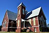 | September 20, 1979 (#79000383) | 709 Martin Luther King, Jr. St. 32°24′51″N 87°01′04″W / 32.414167°N 87.017778°W / 32.414167; -87.017778 (First Baptist Church) | Selma | Historically African American Baptist church, built in the Gothic Revival style in 1894. Known for its association with the Civil Rights Movement. |
| 12 | J. Bruce Hain House |  | November 30, 2001 (#01001295) | 5826 State Route 41 32°17′17″N 86°59′14″W / 32.288056°N 86.987222°W / 32.288056; -86.987222 (J. Bruce Hain House) | Sardis | |
| 13 | Icehouse Historic District |  | June 28, 1990 (#90000886) | Roughly bounded by Jefferson Davis and Dallas Aves., Union and Lapsley Sts., and Valley Creek 32°24′39″N 87°01′54″W / 32.410889°N 87.031653°W / 32.410889; -87.031653 (Icehouse Historic District) | Selma | |
| 14 | Sullivan and Richie Jean Jackson House |  | January 18, 2014 (#13001033) | 1416 Lapsley Ave. 32°25′09″N 87°01′52″W / 32.419070°N 87.031244°W / 32.419070; -87.031244 (Sullivan and Richie Jean Jackson House) | Selma | |
| 15 | Marshall's Grove |  | February 4, 1982 (#82002010) | State Route 22 32°27′58″N 87°00′23″W / 32.466111°N 87.006389°W / 32.466111; -87.006389 (Marshall's Grove) | Selma | |
| 16 | John Tyler Morgan House |  | September 27, 1972 (#72000159) | 719 Tremont St. 32°24′49″N 87°01′39″W / 32.413611°N 87.0275°W / 32.413611; -87.0275 (John Tyler Morgan House) | Selma | |
| 17 | Northern Heights Presbyterian Church | Upload image | June 24, 2022 (#100007813) | 1575 Marie Foster St. 32°25′15″N 87°00′52″W / 32.4209°N 87.0144°W / 32.4209; -87.0144 (Northern Heights Presbyterian Church) | Selma | |
| 18 | Old Town Historic District |  | May 3, 1978 (#78000486) | Roughly bounded by the Alabama River, Jefferson Davis Ave., Pettus, Broad, and Franklin Sts.; also Jefferson Davis Ave.; an area roughly bounded by Broad, Dallas, U.S. Route 80, and Franklin; Selma Ave.; and Franklin St. 32°24′37″N 87°01′31″W / 32.410201°N 87.025323°W / 32.410201; -87.025323 (Old Town Historic District) | Selma | Boundaries after the "also" represent a boundary increase of December 15, 2003 |
| 19 | Edmund Pettus Bridge |  | February 27, 2013 (#13000281) | U.S. Route 80 across the Alabama River 32°24′20″N 87°01′07″W / 32.4056°N 87.0186°W / 32.4056; -87.0186 (Edmund Pettus Bridge) | Selma | |
| 20 | Wesley Plattenburg House |  | February 3, 1993 (#92001827) | 601 Washington St. 32°24′50″N 87°01′20″W / 32.413889°N 87.022222°W / 32.413889; -87.022222 (Wesley Plattenburg House) | Selma | |
| 21 | Pleasant Hill Presbyterian Church |  | April 22, 1999 (#99000465) | 0.2 miles (0.32 km) east of the junction of County Roads 7 and 12 32°09′53″N 86°54′30″W / 32.164722°N 86.908333°W / 32.164722; -86.908333 (Pleasant Hill Presbyterian Church) | Pleasant Hill | Wooden-framed Presbyterian church, built in the Greek Revival style in 1851. |
| 22 | Riverdale |  | September 10, 1979 (#79000384) | Northeast of Selma on River Rd. 32°26′02″N 86°52′11″W / 32.433889°N 86.869722°W / 32.433889; -86.869722 (Riverdale) | Selma | |
| 23 | Riverview Historic District |  | June 28, 1990 (#90000887) | Roughly bounded by Selma Ave., Satterfield and Lapsley Sts., and the Alabama River 32°24′11″N 87°01′51″W / 32.4031°N 87.0307°W / 32.4031; -87.0307 (Riverview Historic District) | Selma | |
| 24 | St. Luke's Episcopal Church | 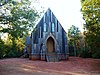 | March 25, 1982 (#82002008) | Beech St. (Cahaba Rd.) near intersection with Capitol Ave. 32°19′09″N 87°06′19″W / 32.3192°N 87.1053°W / 32.3192; -87.1053 (St. Luke's Episcopal Church) | Cahaba | Wooden-framed Episcopal church, built in the Carpenter Gothic style in 1854. |
| 25 | St. Paul's Episcopal Church |  | March 25, 1975 (#75000311) | 210 Lauderdale St. 32°24′31″N 87°01′18″W / 32.4086°N 87.0217°W / 32.4086; -87.0217 (St. Paul's Episcopal Church) | Selma | Brick Episcopal church, built in the Gothic Revival style in 1875. |
| 26 | Selma University Historic District |  | July 14, 2023 (#100009126) | 1501 Boynton St. 32°25′13″N 87°01′54″W / 32.4202°N 87.0317°W / 32.4202; -87.0317 (Selma University Historic District) | Selma | |
| 27 | Marcus Meyer Skinner House |  | August 27, 1987 (#87001418) | 2612 Summerfield Rd. 32°26′15″N 87°02′01″W / 32.4374°N 87.0335°W / 32.4374; -87.0335 (Marcus Meyer Skinner House) | Selma | |
| 28 | Street Manual Training School |  | July 28, 1999 (#99000891) | 263 County Road 38 32°06′49″N 87°03′35″W / 32.1137°N 87.0596°W / 32.1137; -87.0596 (Street Manual Training School) | Richmond and Minter | |
| 29 | Sturdivant Hall |  | January 18, 1973 (#73000340) | 713 Mabry St. 32°24′47″N 87°01′44″W / 32.4131°N 87.0289°W / 32.4131; -87.0289 (Sturdivant Hall) | Selma | Greek Revival style mansion designed by Thomas Helm Lee and completed in 1856. |
| 30 | Summerfield District |  | March 1, 1982 (#82002011) | Selma-Summerfield and Marion Rds., Centenary and College Sts. 32°31′03″N 87°02′45″W / 32.5174°N 87.0458°W / 32.5174; -87.0458 (Summerfield District) | Summerfield | |
| 31 | Tabernacle Baptist Church |  | July 10, 2013 (#13000469) | 1431 Broad St. 32°25′11″N 87°01′28″W / 32.4196°N 87.0245°W / 32.4196; -87.0245 (Tabernacle Baptist Church) | Selma | |
| 32 | Todd House |  | January 29, 1987 (#86003665) | Southern side of Oak St. west of 1st Ave. 32°39′21″N 86°55′52″W / 32.6558°N 86.9311°W / 32.6558; -86.9311 (Todd House) | Plantersville | |
| 33 | U.S. Post Office Building |  | March 26, 1976 (#76000322) | 908 Alabama Ave. 32°24′27″N 87°01′15″W / 32.4075°N 87.0208°W / 32.4075; -87.0208 (U.S. Post Office Building) | Selma | Beaux-Arts style Federal Government building designed by James Knox Taylor and completed in 1909. |
| 34 | Valley Creek Presbyterian Church |  | May 28, 1976 (#76000323) | North of Selma on Valley Creek Rd. 32°28′14″N 87°01′28″W / 32.4706°N 87.0244°W / 32.4706; -87.0244 (Valley Creek Presbyterian Church) | Valley Grande | Brick Presbyterian church, built in the Greek Revival style in 1857. |
| 35 | Water Avenue Historic District | 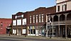 | December 26, 1972 (#72000160) | Water Ave.; also Water Ave. bounded by Lauderdale, MLK Boulevard, Beech Creek, and the Alabama River 32°24′27″N 87°01′00″W / 32.4075°N 87.0168°W / 32.4075; -87.0168 (Water Avenue Historic District) | Selma | Second set of boundaries represents boundary increases approved July 7, 2005 and June 25, 2021 |
See also
Wikimedia Commons has media related to National Register of Historic Places in Dallas County, Alabama.
- List of National Historic Landmarks in Alabama
- National Register of Historic Places listings in Alabama
References
- ^ The latitude and longitude information provided in this table was derived originally from the National Register Information System, which has been found to be fairly accurate for about 99% of listings. Some locations in this table may have been corrected to current GPS standards.
- ^ National Park Service, United States Department of the Interior, "National Register of Historic Places: Weekly List Actions", retrieved June 21, 2024.
- ^ Numbers represent an alphabetical ordering by significant words. Various colorings, defined here, differentiate National Historic Landmarks and historic districts from other NRHP buildings, structures, sites or objects.
- ^ The eight-digit number below each date is the number assigned to each location in the National Register Information System database, which can be viewed by clicking the number.
- v
- t
- e
by county
- Autauga
- Baldwin
- Barbour
- Bibb
- Blount
- Bullock
- Butler
- Calhoun
- Chambers
- Cherokee
- Chilton
- Choctaw
- Clarke
- Clay
- Cleburne
- Coffee
- Colbert
- Conecuh
- Coosa
- Covington
- Crenshaw
- Cullman
- Dale
- Dallas
- DeKalb
- Elmore
- Escambia
- Etowah
- Fayette
- Franklin
- Geneva
- Greene
- Hale
- Henry
- Houston
- Jackson
- Jefferson
- Lamar
- Lauderdale
- Lawrence
- Lee
- Limestone
- Lowndes
- Macon
- Madison
- Marengo
- Marion
- Marshall
- Mobile
- Monroe
- Montgomery
- Morgan
- Perry
- Pickens
- Pike
- Randolph
- Russell
- St. Clair
- Shelby
- Sumter
- Talladega
- Tallapoosa
- Tuscaloosa
- Walker
- Washington
- Wilcox
- Winston

| ||
|---|---|---|
| National Historic Landmark |
|  |
| Historic districts |
| |
| Other properties |
| |
See also: National Register of Historic Places listings in Dallas County, Alabama and List of National Historic Landmarks in Alabama | ||
Municipalities and communities of Dallas County, Alabama, United States | ||
|---|---|---|
County seat: Selma | ||
| Cities |  | |
| Town | ||
| CDP | ||
| Unincorporated communities | ||
| Ghost town | ||
| ||


