Margalef
Municipality in Catalonia, Spain
Seal
 Spain
Spain Catalonia
 (2018)[3]
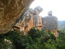

Margalef is a village in Catalonia, Spain. It is situated on the edge of Montsant and is a popular ecotourism destination, especially among rock climbers. The rock type is conglomerate and it has more than 1500 climbing routes of different grades, from 4 to 9b+. Many of the buildings in the village are also built on conglomerate formations.
Margalef's important economic activity is agriculture, mainly producing olives, almonds, and fruits.
References
- ^ "Ajuntament de Margalef". Generalitat of Catalonia. Retrieved 2015-11-13.
- ^ "El municipi en xifres: Margalef". Statistical Institute of Catalonia. Retrieved 2015-11-23.
- ^ Municipal Register of Spain 2018. National Statistics Institute.
External links
- Official website
- Government data pages (in Catalan)
- All about rock climbing in Margalef
Places adjacent to Margalef | ||||||||||||||||
|---|---|---|---|---|---|---|---|---|---|---|---|---|---|---|---|---|
| ||||||||||||||||


- v
- t
- e
Municipalities of Priorat
- Bellmunt del Priorat
- La Bisbal de Falset
- Cabacés
- Capçanes
- Cornudella de Montsant
- Falset
- La Figuera
- Gratallops
- Els Guiamets
- El Lloar
- Margalef
- Marçà
- El Masroig
- El Molar
- La Morera de Montsant
- Poboleda
- Porrera
- Pradell de la Teixeta
- La Torre de Fontaubella
- Torroja del Priorat
- Ulldemolins
- La Vilella Alta
- La Vilella Baixa


| Authority control databases |
|
|---|
 | This Province of Tarragona location article is a stub. You can help Wikipedia by expanding it. |
- v
- t
- e


