Islands of Furness


Walney Island
Barrow Island
Sheep Island
Roa
Island
Island
Piel
Island
Island
Foulney Island
Dova
Haw
Haw
Headin Haw
class=notpageimage|
The islands (except Chapel) in the former Borough of Barrow-in-Furness district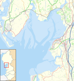
Walney
Barrow
Sheep
Roa
Piel
Foulney
Chapel
class=notpageimage|
The larger islands on a map of Morecambe BayThe Islands of Furness are situated to the south-west and east of the Furness Peninsula. Within England, they are the third biggest collection of islands. They are generally quite small, though at 12.99 km2 Walney Island is the eighth biggest in England. Of these, only Walney Island, Barrow Island, Roa Island and Piel Island are inhabited. The majority of the islands lay within the boundary of the former Borough of Barrow-in-Furness, with some 15,000 residents constituting 20% of the district's population. They are the largest group of islands between Anglesey in Wales and the Firth of Clyde in Scotland.
The main islands are:
- Walney Island - Population 10,651 (Settlements include Biggar, North Scale, North Walney and Vickerstown)
- Barrow Island - Population 2,616
- Sheep Island - Population 0
- Roa Island - Population ~100
- Piel Island - Population ~10
- Foulney Island - Population 0
- Chapel Island - Population 0
As well as these, the small islets of Dova Haw, also known as Crab Island[1][2] and Headin Haw[1] sit in Walney Channel, whilst the old Ramsey Island is now, like Barrow Island, part of the docks system.[1][3]
Chapel, Piel, Foulney and Sheep Islands are tidal and can be walked to at low tide, with appropriate care. Anyone wishing to walk to Piel and Chapel Islands should seek local advice as fast tides and quicksands can be extremely dangerous.[4]
See also
 Cumbria portal

References
- ^ a b c The islands of Furness BBC Cumbria. 22-05-08. Accessed 12-01-10
- ^ Dova Haw WalneyIsle.com. Accessed 12-01-10
- ^ Beachcomber Archived 2011-06-04 at the Wayback Machine The Furness and South Cumbria Beach Clean Group. Accessed 12-01-10.
- ^ No Boat Required – Exploring Tidal Islands, Peter Caton, 2011, Troubador Publishing, ISBN 978-1848767-010
54°06′14″N 3°15′00″W / 54.1039°N 3.25°W / 54.1039; -3.25
- v
- t
- e


