Horki District
District of Mogilev Region, Belarus
You can help expand this article with text translated from the corresponding article in Belarusian. (February 2024) Click [show] for important translation instructions.
- Machine translation, like DeepL or Google Translate, is a useful starting point for translations, but translators must revise errors as necessary and confirm that the translation is accurate, rather than simply copy-pasting machine-translated text into the English Wikipedia.
- Do not translate text that appears unreliable or low-quality. If possible, verify the text with references provided in the foreign-language article.
- You must provide copyright attribution in the edit summary accompanying your translation by providing an interlanguage link to the source of your translation. A model attribution edit summary is
Content in this edit is translated from the existing Belarusian Wikipedia article at [[:be:Горацкі раён]]; see its history for attribution. - You may also add the template
{{Translated|be|Горацкі раён}}to the talk page. - For more guidance, see Wikipedia:Translation.
District in Mogilev Region, Belarus
Horki District Горацкі раён (Belarusian) | |
|---|---|
District | |
 Flag  Coat of arms | |
 | |
| Coordinates: 54°17′N 30°59′E / 54.283°N 30.983°E / 54.283; 30.983 | |
| Country | Belarus |
| Region | Mogilev Region |
| Administrative center | Horki |
| Area | |
| • Total | 1,284.31 km2 (495.87 sq mi) |
| Elevation | 221 m (725 ft) |
| Population (2023)[1] | |
| • Total | 38,180 |
| • Density | 30/km2 (77/sq mi) |
| Time zone | UTC+3 (MSK) |
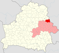
Horki District (Belarusian: Горацкі раён; Russian: Горецкий район, romanized: Goretsky rayon) is a district (raion) of Mogilev Region in Belarus. The administrative center is the town of Horki.[1] As of 2009, its population was 47,800. The population of Horki accounts for 68.6% of the district's population.[2]
The district is situated in the North-East part of the region. It was formed on 17 July 1924. It occupies 1284 km2 and its population is about 46,000 of people. The district is divided into 11 rural stations. On its territory are situated 172 rural populated villages. The district contains the Belarusian State Agricultural Academy and a pedagogical college founded in 1840. These conditions make Horki the center of agricultural science and research. The industry of the district consists of food enterprises, building materials enterprises, light industry enterprises. Agriculture of the district has several main branches: milk and meat cattle-breeding; grain and fodder crops growing; potato growing. Through the territory of Horki district railway Vorša-Kryčaŭ runs. Roads connect Horki with Vorša, Mahiloŭ, Mścisłaŭ and Drybin. Every year 290 thousand of passengers use local railway station and 5.5 million passengers use Horki bus station. The most famous museum of the district is the Memorial complex of “soviet-polish friendship” in Ramanava (Lenina) village. On the territory of Horki district the Pronia, Basia, Ramiastvianka, Lebiedzieŭka, Dniaprec, Miareja run. The useful minerals are peat, sands, and clays.
References
- ^ a b "Численность населения на 1 января 2023 г. и среднегодовая численность населения за 2022 год по Республике Беларусь в разрезе областей, районов, городов, поселков городского типа". belsat.gov.by. Archived from the original on 17 April 2023. Retrieved 5 August 2023.
- ^ Численность населения областей и районов: Могилевская (PDF) (in Russian). Национальный статистический комитет Республики Беларусь. Archived from the original (PDF) on 18 September 2010. Retrieved 13 March 2012.
- v
- t
- e
Subdivisions of Mogilev Region, Belarus
(raiony)
Authority control databases | |
|---|---|
| International |
|
| National |
|
| Other |
|
 | This Belarus location article is a stub. You can help Wikipedia by expanding it. |
- v
- t
- e


